Upcoming rides I'm leading:
Nothing on the schedule.

Show blog entries about: Upcoming rides | Ride reports | My own training

Red Hills and Kayenta (11/12/2016)

Date: Saturday, November 12
Meet time: 10:00 a.m. MST
Ride-out time: 10:30 a.m. MST
Meeting place: Maverik, 995 E. St. George Blvd. (map)
City: St. George, Utah
Rain policy: Rain cancels; make-up date is Nov. 13
Pace: 2 - medium pace
Terrain: 3 - rolling hills with some steep climbs
Miles: 34

Autumn in southern Utah is a perfect time to ride! It's only about two hours (or maybe even a little less) from Las Vegas, and you get to see the amazing Virgin River Gorge on your way up and back.

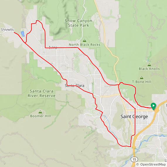
We'll meet just off I-15 Exit 8 in the heart of St. George, and we don't waste any time getting right into the climbing. We begin with a climb of about 350 feet in the first two miles up Red Hills Parkway, and you'll immediately see some of the breathtaking scenery that makes this such a wonderful place to ride. Next, we'll head up Snow Canyon Parkway through Ivins and into the desert community of Kayenta with its smooth, almost-empty roads that attract cyclists from all around.

We'll ride out to the Shivwits Band of Paiute Indians reservation for our rest stop, and then we'll head back through Ivins and into Santa Clara on a glorious new bike lane that was recently added. We'll head back into St. George and slowly climb through the historic downtown district on our way to our final climb, back up Red Hills Parkway in the other direction and then back down to our meeting point.

Ride With GPS reports about 2,000 feet of climbing for this ride. Food, water, and toilets are available inside Maverik. Park and meet in the rear parking lot behind the gas station, near Denny's. Look for the ALC banner!

Nevada riders, note: St. George is on Mountain Time, one hour ahead of Las Vegas.

Click here to RSVP now
Please RSVP so I can plan appropriately.

Three Sisters and Wetlands Park (11/19/2016)

Date: Saturday, November 19
Meet time: 8:30 a.m.
Ride-out time: 9:00 a.m.
Meeting place: Fiesta Henderson, 777 West Lake Mead Parkway (map)
City: Henderson, Nevada
Rain policy: Rain cancels; make-up date is Nov. 20
Pace: 2 - medium pace
Terrain: 3 - rolling hills with some steep climbs
Miles: 36

For our first Henderson ride of this season, we'll spend much of the day on some of the area's excellent paved pathways. And when I say "pathway," don't think it's all flat and easy -- there are a couple of "interesting" climbs on today's route.

We start with a few miles of very gentle climbing on the Union Pacific Railroad Trail, which gains about 400 feet of elevation on its way to the edge of Henderson. Then we'll make a quick connection under 515/95/93 to join the River Mountains Trail, and we'll conquer the Sisters, a series of short but moderately steep hills, but in the easier direction. We'll take our rest stop near Lake Las Vegas area, and then we'll circle around the north hills of Lake Las Vegas before we pick up the Wetlands Park trail, 6 miles of rollercoaster-type hills up and down and around the desert. After that, it's a bit of city-style riding on Gibson Road before we again pick up the Union Pacific trail for our last mile back to the Fiesta.

Ride With GPS reports about 1,700 feet of climbing for this ride. The Fiesta is freeway-convenient, right at the end of the 215 where it meets 95. Toilets, water, and a Starbucks are available inside the Fiesta. Park and meet in the rear parking lot partway up the hill on Fiesta Henderson Blvd., near the train tracks. Look for the ALC banner!

Click here to RSVP now
Please RSVP so I can plan appropriately.

Blue Diamond loop (11/5/2016)

Date: Saturday, November 5
Meet time: 8:00 a.m.
Ride-out time: 8:30 a.m.
Meeting place: McGhie's, 4035 S. Fort Apache Rd. (map)
City: Las Vegas, Nevada
Rain policy: Rain cancels; make-up date is November 6
Pace: 2 - medium pace (10-12mph)
Terrain: 2 - rolling hills
Miles: 31

We'll do the loop out to Blue Diamond and back, this time in the direction with the more gradual but somewhat longer climb -- only 1,300 feet over 15 miles, so it's really not too bad at all. And after that, it's all downhill for the rest of the ride! Experienced riders who want a more robust ride can optionally add the Red Rock Canyon scenic loop for another 1,200 feet and 13 miles.

McGhie's won't be open early in the morning when we ride out, but park and meet in the back of the parking lot away from the main entrance. Look for the black pickup truck with all the ALC stuff! Several gas stations and mini-marts with toilets, food, and water are nearby.

You don't have to be registered for ALC 2017 to join us on our training rides! In fact, we hope that after you've ridden with us, you'll be motivated to join us for the main event from San Francisco to Los Angeles next June ... registration for ALC 2017 is still open.

Click here to RSVP now
Please RSVP so I can plan appropriately.

ALC 2017 Las Vegas kickoff ride (10/15/2016)

Date: Saturday, October 15
Meet time: 8:00 a.m.
Ride-out time: 8:30 a.m.
Meeting place: McGhie's, 4035 S. Fort Apache Rd. (map)
City: Las Vegas, Nevada
Rain policy: Rain cancels; make-up date is October 16
Pace: 2 - medium pace (10-12mph)
Terrain: 2 or 3 - rolling hills with some steep climbs
Miles: 23 or 34

Let's ride! The ALC 2017 training season is officially underway. And we start our season in Las Vegas with a classic route ... and with two options, one with a bit of climbing, and one with a bit more climbing.

Red Rock Canyon is one of the most popular cycling destinations in the entire Las Vegas area, and for good reason. Today we'll start in southwest Las Vegas and head up the I-215 trail for a few miles before we pick up Charleston Blvd. to head west out of civilization and into the canyon. We'll slowly climb most of the way -- nothing too terribly steep, and if the wind is just right, you might not even realize that you're climbing much at all.

When we get to the entrance for the 12-mile Red Rock Canyon scenic loop, you've got an option. You can head just a couple more miles up the main highway, turn around at the canyon overlook, and head back to Las Vegas the way you came. That will give you a ride of about 23 miles and about 1,300 feet of climbing. Or, if you've got a few cycling miles under your belt, you can tackle the scenic loop, return to the canyon overlook, and rejoin the 23-mile riders back to Las Vegas for a total ride of about 34 miles and a more robust 2,500 feet of climbing. The scenic loop contains some moderately steep climbs and descents and is for experienced cyclists.

McGhie's won't be open early in the morning when we ride out, but park and meet in the back of the parking lot away from the main entrance. Look for the black pickup truck with all the ALC stuff! Several gas stations and mini-marts with toilets, food, and water are nearby.

You don't have to be registered for ALC 2017 to join us on our training rides! In fact, we hope that after you've ridden with us, you'll be motivated to join us for the main event from San Francisco to Los Angeles next June ... registration for ALC 2017 is still open.

Click here to RSVP now
Please RSVP so I can plan appropriately.

Mystery ride to Jean (4/23/2016)

Date: Saturday, April 23
Meet time: 7:00 a.m. Note earlier meet time!
Ride-out time: 7:30 a.m.
Meeting place: Sunset Station, 1301 W. Sunset Rd. (map)
City: Henderson, Nevada
Rain policy: Rain cancels; make-up date is April 24
Pace: 3 - medium-brisk pace (12-15mph)
Terrain: 2 - rolling hills
Miles: 60

With only about a half-dozen turns in the space of 60 miles, this is one of our least complicated routes of the entire season, as we head down old U.S. 91 -- roughly parallel to I-15 and with almost no traffic -- to the Gold Strike at Jean, turn around, come back up the old highway, and return to Henderson on St. Rose Parkway. So why the mystery?

The weather is the mystery ... specifically, the wind. If the wind is light, this is a superbly mellow ride with no big hills and a lot of open-road cycling similar to that in the middle days of the event in June. If the wind is stronger and out of the north or south, then half of our day will be challenging and the other half will be quite literally a breeze. And if the wind is strong and out of the east or west, we might be fighting nasty crosswinds for almost the entire day. But no matter how you slice it, the final 20 miles of the day are all gently downhill.

Ride With GPS reports only about 1,900 feet of climbing for this ride. Toilets, water, and a Starbucks (of course) are available inside Sunset Station. Park and meet in the east-side parking lot, off Marks Street near the hotel entrance. Follow the signs for "Meeting Rooms," and look for the black truck with ALC goodies.

Click here to RSVP now
Please RSVP so I can plan appropriately.

Hoover Dam and Bridge (3/26/2016)

Date: Saturday, March 26
Meet time: 8:00 a.m.
Ride-out time: 8:30 a.m.
Meeting place: Fiesta Henderson, 777 West Lake Mead Parkway (map)
City: Henderson, Nevada
Rain policy: Rain cancels; make-up date is March 27
Pace: 2 - medium pace
Terrain: 3 - rolling hills with some steep climbs
Miles: 54

Get ready for an epic ride all the way into Arizona! From our meeting point on the south edge of Henderson, we'll ride the Union Pacific and River Mountain trails into Boulder City for our first rest stop. After that, the real fun begins. We'll get on Highway 93 and quickly descend almost 1,000 feet (good practice for the morning of Day 6) into the Lake Mead National Recreation Area. We'll stay on 93 as it becomes a freeway (also good practice for the event) and descends even more to the Mike O'Callaghan-Pat Tillman Memorial Bridge, which takes us across the state line into Arizona.

When we reach the first exit in Arizona, we'll leave the freeway, turn around, and head back across the bridge on the wide, smooth shoulder ... and where the throngs of sightseers on the separate walkway will undoubtedly gawk at the sight of bicyclists and might even take a picture of you to show the folks back home.

As if that weren't enough, next we'll descend all the way down to Hoover Dam itself and ride across the top of the dam, just back across the state line into Arizona, before turning around and beginning the moderately steep climb back up to Highway 93 and the entrance to the Lake Mead scenic drive.

But wait, there's more! We'll then ride the River Mountains Trail (no fee for riding the trail) along the edge of Lake Mead and all the way around the recreation area for about 14 miles and up to the Lake Las Vegas area. (This is a more gentle ascent than the steep hill on Highway 93 that we descended earlier in the day.) And after a final rest stop, it's an easy ride (albeit with a bit more traffic) back to the Fiesta.

Ride With GPS reports about a robust 4,200 feet of climbing for this ride. Toilets, water, and a Starbucks (of course) are available inside the Fiesta. Park and meet in the rear parking lot partway up the hill on Fiesta Henderson Blvd. just past the parking garage, toward the train tracks.

Important: This ride passes through a mandatory Homeland Security checkpoint on the access road to Hoover Dam. Although ID checks and searches are rare, bring a photo ID and, if you aren't a U.S. citizen, proof of citizenship.

Click here to RSVP now
Please RSVP so I can plan appropriately.

Lake Mead (2/27/2016)

Date: Saturday, February 27
Meet time: 8:30 a.m. Note earlier meet time!
Ride-out time: 9:00 a.m.
Meeting place: Sunset Station, 1301 W. Sunset Rd. (map)
City: Henderson, Nevada
Rain policy: Rain cancels; make-up date is Feb. 28
Pace: 2 - medium pace
Terrain: 3 - rolling hills with some steep climbs
Miles: 50

The Lake Mead National Recreation Area offers superb and scenic road cycling just minutes away from the hustle and bustle of metro Las Vegas. Today, we'll explore one corner of that vast area as we descend to the lake and conquer the climb back up through Boulder City.

Before we get to Lake Mead, however, we'll start with a special short bonus climb: the loop around Lake Las Vegas and then back up to Lake Mead Parkway. That will get us to our first rest stop of the day at the River Mountains Bike Shop. After that, we'll go down the hill to the Lake Mead entrance gate, where you'll need to either pay a $5 cyclist fee or show a valid entrance pass (such as the nationwide America the Beautiful pass). This is our gateway to Lakeshore Road, 12 miles of rolling hills that trend gradually downward to the lake and provide striking views of the lake and its "bathtub ring."

Since we descend to the lake, we also have to climb back up. We'll use the River Mountains Trail, which is a longer but far more gentle climb that the hill on Highway 93 that motorists use. When we reach Boulder City, we'll take another rest stop, and then we'll bypass the steepest part of the trail (the part we did on our last ride) and take a short cut to pick up the trail again on the other side of the city. We'll deal with Railroad Pass again (hoping that the winds aren't as strong this time), and after that it's all downhill back to Henderson.

Ride With GPS reports about 2,800 feet of climbing for this ride. Toilets, water, and a Starbucks (of course) are available inside Sunset Station. Park and meet in the east-side parking lot, off Marks Street near the hotel entrance. Follow the signs for "Meeting Rooms," and look for the black truck with ALC goodies.

Click here to RSVP now
Please RSVP so I can plan appropriately.

Boulder City (2/6/2016)

Date: Saturday, February 6
Meet time: 9:00 a.m.
Ride-out time: 9:30 a.m.
Meeting place: Sunset Station, 1301 W. Sunset Rd. (map)
City: Henderson, Nevada
Rain policy: Rain cancels; make-up date is Feb. 7
Pace: 2 - medium pace
Terrain: 3 - rolling hills with some steep climbs
Miles: 42

Shake the cobwebs off the derailleurs, and join us as we head south to Boulder City for a fun day on roads, paths, and yes, even a few interesting hills.

After a few miles of gentle warmup, we start with the climb up Horizon Ridge to Paradise Hills, and we'll make our way to the River Mountains Trail. Then we'll head west up and over Railroad Pass, alongside U.S. 93, and into the outskirts of Boulder City. We'll do a big loop around the city, starting with a long and gradual descent toward the airport and continuing with a gentle climb up Georgia Avenue and over to the Nevada Way historic district and our rest stop at mile 21.

After that, we'll explore a little more of the city before making our way under U.S. 93 to again pick up the River Mountains Trail. We'll ride the trail -- which includes the twisty, moderately steep climb to the trail's high point at an elevation of just under 2,700 feet -- all the way back to Henderson, where we'll hop on the Union Pacific Trail and take it to the 215.

Ride With GPS reports about 2,000 feet of climbing for this ride. Toilets, water, and a Starbucks (of course) are available inside Sunset Station. Park and meet in the east-side parking lot, off Marks Street near the hotel entrance. Follow the signs for "Meeting Rooms," and look for the black truck with ALC goodies.

Click here to RSVP now
Please RSVP so I can plan appropriately.