Upcoming rides I'm leading:
Nothing on the schedule.

Show blog entries about: Upcoming rides | Ride reports | My own training

Palm Springs Snowbird Ride (12/20/2011)

Date: Tuesday, December 20
Meet time: 10:30 a.m.
Ride-out time: 10:45 a.m.
Meeting place: Best Western Inn at Palm Springs, 1633 S. Palm Canyon Drive (map)
City: Palm Springs
Rain policy: Rain, ice, or strong wind cancels
Category: 3 - moderate-fast pace (12-15 mph)
Terrain: 2 - rolling hills
Miles: 51

Description:
Spread your tiny wings and fly away,
And take the snow back with you where it came from on that day.


Visiting Palm Springs for the holidays? So are some of your DSSF friends. Bring your bike and join us for a ride!

This route starts near downtown Palm Springs and heads eastbound on city arterials toward Palm Desert before climbing up Thousand Palms Canyon and onto the famous Dillon Road, known for its frequent starring role in the Tour de Palm Springs. But because it's December and daylight is short, we'll only go as far as Desert Hot Springs before heading back.

RideWithGPS says 1,655 feet of climbing, but it's probably a bit less than that. You'll have about six hours to complete the route before sunset, so pace yourself accordingly.

Unfavorable weather of any type -- including very cold temperatures or very strong winds -- cancels. RSVP is required so the ride leader can keep you updated if needed.

Meet time 10:30, ride-out at 10:45. Dressing like Anne Murray is not required.

This ride is listed with Different Spokes San Francisco, so DSSF waivers will be used. DSSF membership is not required.


RSVP required for this ride.

Las Vegas: New Year's at the Lake (1/1/2012)

Date: Sunday, January 1
Meet time: 10:45 a.m.
Ride-out time: 11:00 a.m. sharp
Meeting place: Fiesta Henderson, 777 W. Lake Mead Pkwy. (map)
City: Henderson, Nevada
Rain policy: Rain, ice, or snow cancels
Category: Open pace; all are welcome
Terrain: 3 - rolling hills with some steep climbs
Miles: 40

Description:

Visiting Las Vegas for New Year's? Bring your bike with you! Part of the Vegas ALC crew? Join us! Las Vegas' very own official ALC training ride leader, Aaron Otte, will be one of your leaders today.

We're going to start 2012 in grand style with a scenic loop ride through the Lake Mead National Recreation Area. As we descend about 600 feet to lake level, we'll have picturesque views of the lake and (for out-of-towners) an up-close look at the receding lake level and its effect on the area's geology.

Then we'll join the River Mountains Trail to take us up the big hill into and through Boulder City. (Depending on whether there have been any recent rains to flood the combination bike path and drainage channel, we might have to ride part of this leg on the shoulder of Highway 93.) After climbing about 1,400 feet from lake level, we'll reach the high point of the day and then have 10 miles of gentle downhill back into Henderson.

The Lake Mead NRA charges $3 (or a valid national park pass) for bicyclists to use the road. Food and water are very limited along this route, so plan on bringing enough to get you through the entire ride. Convenience stores are located in the first couple of miles and again just off the route near Mile 26, but there's not much of anything before that. Because this is a somewhat long ride with limited services, it's not suitable for beginning cyclists, but Aaron promises plenty of beginner-friendly Las Vegas training rides in 2012. You'll have a little more than five hours of daylight to complete the route, so pace yourself accordingly.

We will meet in the rear parking lot of Fiesta Henderson, across from the parking garage. Look for crazy people with bicycles. Plenty of free parking, and there's a Starbucks inside. (What? You thought I'd have a ride without a Starbucks?)

If the mid-morning temperature is expected to be below freezing, we won't ride. Please RSVP so we can keep you informed about any weather-related developments.

This is a renegade ride, not an official part of AIDS/LifeCycle, but we will follow ALC safety rules.


RSVP required for this ride.

Distance Training #1: Woodside (1/14/2012)

Date: Saturday, January 14
Meet time: 9:30 a.m.
Ride-out time: 10:00 a.m.
Meeting place: New location! Parking lot at Villa and Franklin streets, Mountain View (across from the Tied House) (map)
City: Mountain View
Rain policy: Heavy rain cancels
Category: 2 - moderate pace (10-12 mph)
Terrain: 2 - rolling hills
Miles: 42

Description:

Entering its fifth season in 2012, the AIDS/LifeCycle Distance Training rides have become a Peninsula and South Bay institution. These rides start in January each year and culminate in mid-May with the Altamont Pass Double Metric.

From our new meeting location in downtown Mountain View, we'll head around the Arastradero Nature Preserve, Portola Valley, Cañada Road, and Edgewood Road with an easy return on Alameda de las Pulgas. No surprise stupid climbs; this is all comparatively tame stuff. About 1,800 feet of climbing total, according to Strava.

This ride is Caltrain- and VTA-friendly. The first southbound train of the day leaves SF at 8:15 and arrives in Mountain View at 9:29. We're about four blocks from the station.


RSVPs are requested but not required.

Early-Bird Ride #4: Fremont (12/17/2011)

Date: Saturday, December 17
Meet time: 9:30 a.m.
Ride-out time: 10:00 a.m.
Meeting place: Parking lot at Villa and Franklin streets, Mountain View (across from the Tied House) (map)
City: Mountain View
Rain policy: Rain cancels
Category: 2 - medium pace (10-12 mph)
Terrain: 1 - mostly flat
Miles: 41

Description:

For our final ride, we'll do a big loop around the southern end of San Francisco Bay. This means that our route will be almost totally flat, except for crossing the Dumbarton Bridge! After we ride through the Don Edwards San Francisco Bay National Wildlife Refuge, we'll pass through Newark on our way to a lunch stop in Fremont. Then it's into Milpitas and San Jose on some multi-use trails that take us into Sunnyvale for our ride along the edge of Moffett Field and our return to Mountain View.

Total climbing on this ride is only about 330 feet, according to Strava.

If you're planning to do our Distance Training rides beginning in mid-January, the early-bird rides are perfect for getting you back up to speed and distance. If you're a new ALCer, these rides are a great introduction to the people and ways of AIDS/LifeCycle.

This ride is Caltrain- and VTA-friendly. The first southbound train of the day leaves SF at 8:15 and arrives in Mountain View at 9:29. We're about four blocks from the station. If you're a veteran of the Mountain View rides, note our new meeting location this year! It's just one block away from our old spot.


RSVPs are requested but not required.

Early-Bird Ride #3: Saratoga (12/10/2011)

Date: Saturday, December 10
Meet time: 9:30 a.m.
Ride-out time: 10:00 a.m.
Meeting place: New location! Parking lot at Villa and Franklin streets, Mountain View (across from the Tied House) (map)
City: Mountain View
Rain policy: Rain cancels
Category: 2 - medium pace (10-12 mph)
Terrain: 3 - rolling hills with some steep climbs
Miles: 33

Description:

For our third ride, we'll begin with the gradual climb into scenic Stevens Canyon (usually a few degrees cooler than Mountain View, so dress accordingly). After that, we've got our first significant climb of the season: Mount Eden, a 0.7-mile hill that can seem intimidating at first. But when you come back to Mount Eden later in your training (and you will, probably many times), you'll be able to measure your progress. A thrilling descent into Saratoga awaits, and then we'll head partway to Los Gatos along Highway 9 before going around the edge of West Valley College and taking an easy return back to Mountain View. (If you know the area already, note that we will *not* be doing the steep climb on Pierce Road.)

Total climbing on this ride is about 1,260 feet, according to Strava.

If you're planning to do our Distance Training rides beginning in mid-January, the early-bird rides are perfect for getting you back up to speed and distance. If you're a new ALCer, these rides are a great introduction to the people and ways of AIDS/LifeCycle.

This ride is Caltrain- and VTA-friendly. The first southbound train of the day leaves SF at 8:15 and arrives in Mountain View at 9:29. We're about four blocks from the station. If you're a veteran of the Mountain View rides, note our new meeting location this year! It's just one block away from our old spot.


RSVPs are requested but not required.

Early-Bird Ride #2: Portola Valley (12/3/2011)

Date: Saturday, December 3
Meet time: 9:30 a.m.
Ride-out time: 10:00 a.m.
Meeting place: New location! Parking lot at Villa and Franklin streets, Mountain View (across from the Tied House) (map)
City: Mountain View
Rain policy: Rain cancels
Category: 2 - medium pace (10-12 mph)
Terrain: 2 - rolling hills
Miles: 28

Description:

For our second ride, we'll travel along Foothill Expressway and go past Stanford University to cycle around the popular Portola Valley loop, one of the nation's most popular recreational cycling routes. (We'll have plenty of company with riders of all paces and skill levels, just like on ALC.) We'll do the climb up Alpine Road, which is 3.4 miles long but very gentle most of the way, topping out at an elevation of less than 600 feet. And our rest stop of the day is right at the top of the hill, so you'll have a good opportunity to rest and refuel. Then, since we went uphill, we get to enjoy going downhill on Portola Road. A couple of short hills will get your attention along the way, but they're not stupidly big. After returning to Stanford and Foothill, we'll return via the bike bridge between Palo Alto and Mountain View.

Total climbing on this ride is about 1,080 feet, according to Strava.

If you're planning to do our Distance Training rides beginning in mid-January, the early-bird rides are perfect for getting you back up to speed and distance. If you're a new ALCer, these rides are a great introduction to the people and ways of AIDS/LifeCycle.

This ride is Caltrain- and VTA-friendly. The first southbound train of the day leaves SF at 8:15 and arrives in Mountain View at 9:29. We're about four blocks from the station. If you're a veteran of the Mountain View rides, note our new meeting location this year! It's just one block away from our old spot.


RSVPs are requested but not required.

Distance Training 2012

The fifth season of Distance Training rides begins Saturday, January 14 in Mountain View. These are challenging rides for intermediate and advanced cyclists, with a focus on increasing distance to and beyond the longest days of AIDS/LifeCycle. For many riders, ALC is as much a mental challenge as it is a physical challenge, and the Distance Training rides are a great opportunity for you to get experience spending long hours in the saddle ... and dealing with all of the issues that come up for you on such long rides.

Here's a quick preview of what I'm planning for this season. As always, the routes and descriptions are subject to change, but this will give you a good idea of what to expect. Distances are approximate. All rides leave our new location across the street from the Tied House on Villa Street in downtown Mountain View (just one block from our old location). All of the climbing numbers are from Strava; stats from RideWithGPS would read a bit higher, and stats from MapMyRide would read a bit lower. Dates are tentative in case we need to schedule around the ALC Expo and Day on the Ride weekends.

1. January 14: Woodside, 42 miles. No real surprises or giant climbs here; just a typical ride through the Arastradero nature preserve and Portola Valley. We'll take Cañada Road as far as Edgewood, where we'll descend and return on Alameda de las Pulgas. 2,036 feet climbing.

2. January 28: Los Gatos, 45 miles. We'll take the gentle route to Saratoga via Quito Road, over to Los Gatos, and then up the Kennedy climb. We'll then hang a left and do the last part of the Shannon climb before returning on Highway 9 through Saratoga. 2,172 feet climbing.

3. February 11: Westridge Plus, 50 miles. This is a ride with a message -- pace yourself. By design, the first half of this route is almost completely flat. But then we shift into a festival of hill-climbing, starting with the Quadbuster-esque Westridge in Portola Valley. This year, there's a new challenge (that's the "plus"): We'll then head up to the bucolic end of Alpine Road and then climb (or, in some cases, cross-train) the fairly short but even steeper Joaquin Road. The reward is an amazing descent down Los Trancos Road back into Portola Valley. 2,877 feet climbing.

4. February 25: Crystal Springs, 59 miles. We start with the rolling hills of Alameda de las Pulgas all the way to San Carlos. After a rest stop, we'll continue on Alameda all the way until it ends in San Mateo, which means a couple of rather significant climbs along the way. Then it's up the Polhemus hill that made its debut on ALC10 (and probably will be back for ALC11), down the Ralston bike path, and back via Cañada Road. 2,890 feet climbing.

5. March 10: Metcalf, 69 miles. New route this year! After taking the gentle route to Los Gatos, we'll do the "Santa Teresa slog" in reverse for the first time and cross over to Monterey Highway, where we'll pick up Metcalf Road, a steep 2-mile climb that's a local favorite and has been part of the Lance Armstrong Livestrong Challenge in San Jose. The good news is that it's the only significant climb of the day; the return is mostly urban along Capitol Expressway, Capitol Ave., and past the Great Mall into Santa Clara. 2,644 feet climbing.

6. March 24: Pacifica, 80 miles. New route this year! We've headed up the Peninsula toward San Francisco in past years, but this year we'll head down to the coast in Pacifica. Of course, this means we have to climb back up from the coast, and we'll do that via Sharp Park Drive, which is somewhat steep but not stupidly so. This ride includes, as we've done in the past, some of the freeway-legal segments of I-280 and closely approximates Day 1 of the ride in terms of both climbing and distance. 5,194 feet climbing.

7. April 7: Palomares/Calaveras, 90 miles. New route this year! We'll head across the bottom of the bay on a flat route to Milpitas, and then make our way up Mission Blvd. to Niles Canyon and tackle the 4.4-mile northbound Palomares climb (the "easier" direction). After a lunch stop in Castro Valley, we'll head across the Dublin Grade (again in the easier direction) and then down Foothill Blvd. into Sunol, where we'll do, yes, the "easier" southbound climb of Calaveras Road. 4,137 feet climbing.

8. April 21: South Bay Century, 100 miles. We used a slightly new route in 2011, and it went very well, so we'll stick with it in 2012. This is a giant loop around the South Bay, starting in the Palo Alto hills, across the Dumbarton Bridge, along the eastern edge of San Jose, around Evergreen College, and then up and over Silver Creek Valley Road, which includes one of the most thrilling urban descents anywhere in the Bay Area. After that, it's a mostly urban return through San Jose, Los Gatos, and Saratoga, which gives tired riders several chances to rest and refuel. About 3,000 feet climbing.

9. May 5: Gilroy, 112 miles. New route this year! We've gone to Gilroy in past years, but this year will be different. We'll take a flat, direct route through downtown San Jose (which should be quite scenic and not very stressful at 7:30 on a Saturday morning) and down Monterey Highway into Morgan Hill. But then we'll climb the eastern foothills and go part of the way to Gilroy Hot Springs before riding along Cañada Road (a different Cañada than on the Peninsula), stopping for lunch in Gilroy, and then riding northbound around the western reservoirs on the way back. This should mean fewer headwinds on the return! About 3,400 feet climbing.

10. May 19: Altamont Pass, 125 miles. The fifth annual Altamont Pass Double Metric! Everything you've heard is probably true: This is an epic ride that has a little bit of everything the Bay Area has to offer, yet it is usually very doable by any ALCer who can maintain the pace that's needed to complete the route within the 14 available hours of daylight. There are no stupidly ridiculous hills on the route; in fact, thanks to the prevailing winds, the descent from the original Altamont Pass on the historic Lincoln Highway often is more challenging than the climb! The final 40 miles of the ride are mostly urban and include a long haul through Hayward, Union City, and Fremont down Mission Blvd., which has been resurfaced since last year and should be less painful. About 2,800 feet climbing, and plenty of stories that you'll tell in the years to come.

Rides 1 and 2 run at an official pace of 10-12 mph. Beginning with Ride 3, the pace increases to 12-15 mph. Faster riders are always welcome, but be sure you know how to read a route sheet so you can navigate on your own.

When RSVPs are open, the rides will be posted both here and in the official ALC training ride calendar.

I look forward to riding with you on the 2012 Distance Training rides.

Photo: At the top of Silver Creek Valley Road on the 2011 South Bay Century.

Early-Bird Ride #1: Cupertino (11/19/2011)

Date: Saturday, November 19
Meet time: 9:30 a.m.
Ride-out time: 10:00 a.m.
Meeting place: New location! Parking lot at Villa and Franklin streets, Mountain View (across from the Tied House) (map)
City: Mountain View
Rain policy: Rain cancels
Category: No pace; all are welcome
Terrain: 2 - rolling hills
Miles: 21

Description:

Welcome to a set of four early-bird rides in Mountain View to get you ready for the upcoming season. (The "early-bird" refers to the pre-season, not the time of day. We have humane meeting times!)

For this first ride, we'll take a simple route through Sunnyvale into Cupertino, where we'll go around De Anza College before tackling our one hill of the day: the very short (0.1 mile) climb up McClellan Road. After that, we'll take a quick rest stop along Foothill Expressway before heading through Los Altos into Palo Alto. Then it's back down Middlefield Road for our return to downtown Mountain View.

Total climbing on this ride is about 500 feet, according to Strava.

If you're planning to do our Distance Training rides beginning in mid-January, the early-bird rides are perfect for getting you back up to speed and distance. If you're a new ALCer, these rides are a great introduction to the people and ways of AIDS/LifeCycle.

This ride is Caltrain- and VTA-friendly. The first southbound train of the day leaves SF at 8:15 and arrives in Mountain View at 9:29. We're about four blocks from the station. If you're a veteran of the Mountain View rides, note our new meeting location this year! It's just one block away from our old spot.


RSVPs are requested but not required.

ALC11 Distance Training Preview (10/22/2011)

Date: Saturday, October 22
Meet time: 9:45 a.m.
Ride-out time: 10:00 a.m.
Meeting place: New location! Parking lot at Villa and Franklin streets, Mountain View (across from the Tied House) (map)
City: Mountain View
Rain policy: Rain cancels
Category: 3 - moderate-fast pace (12-15 mph)
Terrain: 2 - rolling hills
Miles: 42

Description:

Entering its fifth season in 2012, the AIDS/LifeCycle Distance Training rides have become a Peninsula and South Bay institution. These rides start in January each year and culminate in mid-May with the Altamont Pass Double Metric. Although the rides are designed to train ALC riders, they're open to anyone who seeks the challenge.

Join me this Saturday for a preview of the 2012 rides as we "test-ride" the first route. From our (new!) meeting location in downtown Mountain View, we'll head around the Arastradero Nature Preserve, Portola Valley, Cañada Road, and Edgewood Road with an easy return on Alameda de las Pulgas. No surprise stupid climbs; this is all comparatively tame stuff. About 1,800 feet of climbing total.

We'll follow the usual ALC rules on this ride, but there won't be a sweep rider or a SAG vehicle. This ride is presented through Different Spokes San Francisco, so we will sign the DSSF waiver, not the ALC one.

This ride is Caltrain- and VTA-friendly. The first southbound train of the day leaves SF at 8:15 and arrives in Mountain View at 9:29. We're about a four-block walk from the station.

Meet time is 9:45 a.m., and we ride out at 10 a.m. sharp.


RSVPs are requested but not required.

Mountain View ALC11 early-bird training rides

Here is the tentative schedule for this season's early-bird training rides out of Mountain View.

Saturday, November 19: 22 miles to Cupertino and Los Altos, with nothing worse than the McClellan bump.
Saturday, November 26: No ride; Thanksgiving weekend.
Saturday, December 3: 28 miles, Portola Valley (via Alpine, not Westridge).
Saturday, December 10: 32 miles, Saratoga via Mount Eden (but not Pierce).
Saturday, December 17: 41 miles, flat loop around the South Bay including the Dumbarton Bridge.

The fifth annual Distance Training rides tentatively begin Saturday, January 14.

New meeting location: All rides will meet from the parking lot at the corner of Franklin and Villa streets in downtown Mountain View. This is one block south of our former location. We will still be Caltrain- and VTA-friendly, just one block farther away than before.

Whether you're a veteran ALCer or a first-year participant, I look forward to riding with you as we train for AIDS/LifeCycle 11.

(If you're an ALC ride leader who will be certified by ride day, contact me for the link to sign up.)

Ride report: Double Bay Double (9/24/2011 and 9/25/2011)

Go, riders! Go, volunteers!

The first Double Bay Double has gone into the history books, and our 17 riders and our team of incredible volunteers were part of a weekend that quickly uses up the list of available adjectives: amazing, epic, challenging, inspiring, successful ... and one more very important adjective: safe. We had no injuries, we had no significant mechanical failures, every cyclist completed the ride, and we set a positive example for the other cyclists and motorists with whom we shared the road. And to top it all off, when the final accounting is complete, our small group raised about $10,000 for the San Francisco AIDS Foundation.

Day 1: Mountain View to Marina (108 miles)

Our weekend started in the pre-dawn hours of Saturday morning. We gathered at the Franklin/Evelyn parking lot one last time before the lot -- our meeting place for ALC, DSSF, Seismic, and DBD training rides for the past five years -- closes forever next month for the long-promised housing project. After a few opening remarks and a safety speech, we rolled out five minutes early at 6:55 a.m. just as the sun was beginning to rise. The first leg of our ride was quite easy -- just 8 miles on familiar streets into Menlo Park for our first rest stop at Starbucks. Why so soon? Because after that, we wouldn't see much of anything in the way of services for the next 35 miles.

As we left Rest Stop 1, many of us ended up in the middle of groups of cyclists taking part in the Ride for Ravenswood, another charity event that we knew would be following our route as far as San Gregorio. Our small group of cyclists suddenly felt like a much larger group as we crossed over I-280 and conquered Horse Hill as our first significant climb of the day. But that was only a warmup to the day's main event: the 3.3-mile climb of Old La Honda Road, the benchmark of all Peninsula climbs.

When I reached the top, I saw a huge group of cyclists gathered by the side of the road, clustered around one of our support vehicles. Not wanting to contribute to the crowd, I rode on and began my descent of the other side of Old La Honda. What I didn't know at the time was that some of the Ravenswood riders were using the services (especially water and tubes) of our support vehicles because we apparently had supplies available and they did not! SAG driver Taryl was more than generous but eventually had to relent and let them know that her water was for us unless there was a dire need. There was also a brief encounter with a Woodside police officer who thought we were part of the support for the much larger Ravenswood ride, which had generated some complaints about blocking traffic. (As I said before, we set a good example by riding single file and calling out our intentions. I wish other rides were as serious about this.)

As we descended Highway 84 toward the coast, the skies turned gray as the coastal fog became low and thick. By the time we reached our toilet stop at San Gregorio State Beach, it felt more like March or April than late September. But our spirits were brightened considerably by Terri's well-stocked supply vehicle, accompanied by special surprise guests Diana and Frank, two riders from next weekend's Seismic Challenge. (At least I think it was Frank. Some folks weren't so sure!) Aron, our bike tech, set up his stand and was busily tending to the minor issues that arise on the road -- his expert skills no doubt allowed some of our cyclists to finish the ride.

The long ride down Highway 1 to Santa Cruz is a well-worn route that's familiar to AIDS/LifeCycle riders, and most of us knew what to expect in the way of countless small but attention-getting hills (the randonneuring groups call the route "lumpy"). The routine of countless rides past was broken up somewhat by having different rest stop locations -- at Gazos Creek and in Davenport -- but the fog kept the seaside views from being all that they could have been. And the fog was so thick at times that we even had some drizzle, which I especially noticed whenever I would turn my head and a puddle of water would fall down off the top of my helmet!

Santa Cruz is where things became different for most of us. After passing through the city's west side on a bike route different from the one used by ALC, we dealt with the Soquel Drive Slog amid heavy Saturday afternoon traffic that posed challenges similar to those at the beginning of ALC's Day 2. I was near the front of the group at this point, and that was a good thing, because I came across a "turn" that I had failed to include on the route sheet: the right turn "from" Soquel Drive "to" Soquel Drive just past Rio Del Mar Blvd. The turn usually isn't included on ALC or randonneuring route sheets because it's "just one of those things that all the locals know." About half a mile later when I realized what I had just passed, I got on the phone to Adam, our super logistics wizard, and said that we needed to put a person there, but it was too late to prevent at least one of our riders from missing the turn. (Sorry!)

Minor crisis averted, our route then departed from the traditional ALC route and ventured inland (and uphill) toward Corralitos and Freedom on our way to Watsonville. I greatly prefer this route to the lumpy ALC route along the coast and through agricultural flatlands (which also happens to be the official Pacific Coast Bicycle Route), but when we reached Watsonville (at breakneck speed for, thanks to a strong but short-lived tailwind), it became quite clear why the inland route simply wouldn't work for a large group.

Getting through much of the city itself wasn't too bad, but leaving the city and heading south into Monterey County was another story. The road through Pajaro is not well-designed for bicycles, and the heavy local traffic gave us some of the most challenging urban cycling of the day. Moreover, to someone who had never been in the area before, the route to the Elkhorn Slough was a bit confusing in a couple of places, and a few riders ended up with some unexpected bonus miles -- quite a few miles in a couple of cases. This was one of the few times where our randonneuring-style lack of route marking didn't work out so well. (The good news is that, now, you know the route for next time!)

And the terrain around the Elkhorn Slough was another matter entirely! I had warned folks that the short but steep hills in the area would seem especially challenging after 95 miles, and I was right. They just kept coming and coming! In fact, I even lost count at one point and was quite dismayed when I thought I was done with the hills, only to be confronted by yet another one. Traffic in the area, on the other hand, was much lighter than I anticipated, and that made this segment a little less stressful for me.

After a brief toilet stop at the famous Pezzini Farms artichoke stop at mile 103, I successfully negotiated the final few miles on Del Monte Blvd. into Marina. (Path or shoulder? ALC seems to change its mind from time to time and has used both. I put us on the shoulder, but the path was a viable alternative as well, albeit one with extra stop signs.) I arrived at the Motel 6 parking lot ("up the hill," as the route sheet noted, for one final devious twist to the day), where super bag transport volunteer Charlotte was waiting to check me in. After a quick shower, I came back to congratulate the rest of the returning riders -- and I saw the typical mix of joy, excitement, determination, and frustration that comes at the end of such a long and challenging day.

The last rider arrived at about 6 p.m., well ahead of the official 6:30 p.m. route closing time, and about 19 of us (we lost count somewhere along the way) managed to overwhelm Denny's for a lively, free-wheeling dinner, where even more friends of DBD joined us to offer their congratulations and support. As we left dinner and headed to our motel rooms, we were surprised by a quite unexpected light drizzle, casting doubt on what already had been a somewhat unreliable weather forecast.

For me, sleep was definitely not a problem. But longtime ALCers will know that most nights on the ride are punctuated by at least one visit to a toilet or portapotty. I had no such interruption, and this would be significant the next day.

Day 2: Marina to Mountain View (100 miles)

We had been promised cool, foggy conditions for our 7 a.m. ride-out from Marina, but instead we got just higher clouds and temperatures near 60 -- warm enough for many of us to forgo jackets. Our route out of Marina toward Salinas followed the traditional ALC Day 2 route, which didn't stop me from accidentally almost leading our group into a wrong turn along Reservation Road when I headed to a left turn lane one intersection too soon! (And everyone followed me because I obviously knew what I was doing, except that I did not.) Super SAG driver Dennis helped us get back to the correct side of the road.

Salinas had pleasantly light traffic at 8 o'clock on a Sunday morning, so we easily made it to our first rest stop. After that, however, was our big climb of the day: San Juan Grade. It's not all that steep, and it's not as consistently uphill as Old La Honda, and most of our riders made fairly easy work of the climb -- perhaps inspired by the dramatic golden landscape that unfurled as we ascended toward 1,000 feet.

The descent, on the other hand ... well, I warned everyone that it would be rough, and I certainly was right. As we passed the oddly-lettered sign that proclaimed the San Benito County line, the road surface turned to utter crap. This road was one of the first routings of Highway 101 between Gilroy and Salinas, and it's entirely possible that the cracked, patched, rutted, torn-up concrete base on which we descended was part of the original surface from more than 80 years ago. It's hard to believe that funds can't be found to repair this dangerous 3-mile stretch of highway, but one possible reason for not fixing it is that doing so would only encourage more motorists to use this narrow, one-lane road as a bypass for Highway 101.

When we arrived at Rest Stop 2 in San Juan Bautista, super volunteer Danni was there to greet us, and a well-stocked grocery store gave us a mid-morning pick-me-up. A minor crisis was averted when we spotted one of riders exit the rest stop and head the wrong way up Highway 156, but SAG driver Dennis quickly took to the road on a rescue mission.

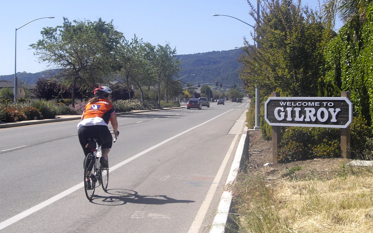
The route from San Juan Bautista to Hollister and then up to Gilroy was all on major, high-speed, busy highways, but nice shoulders kept it from being too annoying. In fact, much as I suspected would be the case, my favorite segment of the entire weekend was along Highway 156 just past the turnoff into Hollister. For me, the combination of valley and mountain terrain and the wide-open landscape was unlike anything else we saw the entire weekend, and I truly had a sense of being somewhere else. And for a special treat, the winds along Highway 25 were not nearly as bad as they often can be, so most of us arrived at the Day 2 halfway mark in Gilroy in rather good form (some of us later than others, due to a few unfortunate flats earlier in the day).

I had a "healthy, hearty meal" at the Togo's in Gilroy, but as soon as I got back on the road, I could feel that something about me wasn't quite right. The first sign -- and one that didn't really register with me at the time -- came even before I left the lunch stop, when I realized that I had not properly paused my GPS route recording while I ate. As I started to ride, I started to fear that maybe I had things backwards and I was actually paused while riding and recording while resting. I quickly stopped by the side of the road to reassure myself that this wasn't the case. But as I continued the gradual, slow climb up Day Road and toward the Uvas Reservoir, I knew that my speed was dropping considerably from the aggressive (for me) pace I had maintained throughout the weekend.

When I reached Terri's toilet stop at the reservoir, I put on a brave face, but I was starting to suffer. I ate one of my two packets of "emergency" energy beans, I drank most of my water and got a refill, I stood around to talk a little bit more than I normally would at an intermediate stop, and I even took off my leg warmers as temperatures appeared to hit the low 70s. That might not have been such a bright idea; almost as soon as I pushed myself back onto Uvas Road, the first sprinkles began to fall on me.

By this point, Uvas Road was trending generally uphill, and even the tiny 2% to 3% grades were giving me difficulty. Just a couple miles up the road, I stopped again (giving SAG driver Taryl a half-hearted thumbs-up as she went by) and took some ibuprofen and a pink bismuth tablet. Just a couple miles later, the sprinkles had turned to a light shower, and I stopped yet again, this time to put on the jacket that I had been carrying all day (but not, oddly enough, to put my leg warmers back on). As the slow climb continued, I still was not having much fun at all. I stopped one more time and ate my second and final bag of beans.

I finally reached the summit of Uvas Road, and as I began to speed downhill, the rain became somewhat stronger, whipping into my face as I was trying to stay under 25 mph. This wasn't "heavy rain" of the type that would have canceled a training ride, but it was still plenty annoying, especially considering my frame of mind at the time.

But then, something changed. The rain stopped, and the double dose of caffeine-laden beans appeared to take effect. (The downhill trend of the road certainly helped a bit, too.) By the time I reached Almaden Expressway on the outskirts of San Jose, I was back mostly to my usual form, although I recall being a tiny bit disoriented when I heard someone yelling "Chris!" at me at a traffic signal ... just Taryl in the lane next to me.) A strawberry-banana smoothie and a salted bagel at the San Jose rest stop helped things considerably, and by the time I left Rest Stop 4, I was ready to again start thinking less about myself and more about everyone else.

The rain had already passed through San Jose, and the streets were a bit damp in places as we headed toward Los Gatos. After passing through downtown, I was quite happy knowing that only two significant climbs remained on the route. Rarely have I been so pleased to finish the short half-mile climb on Highway 9 from Austin Way!

After a quick stop at the final rest stop, I was ready for the mostly-downhill final leg of only 11 miles, and I powered my way down Miramonte Avenue from Los Altos into Mountain View filled with a sense of accomplishment for completing my first-ever back-to-back century rides.

I quickly rode home (another half-mile on the bike!), showered, and returned to the Franklin/Evelyn lot to congratulate the rest of the returning riders (except for one rider who went directly home instead). We didn't have any big banners, balloons, or ceremonies, but the emotions were plenty powerful as cyclist after cyclist arrived at mile 208 with a successful ride.

The last rider beat the official closing time by more than an hour, so 11 of us went for an early celebration dinner in downtown Mountain View.

Then we all went back to the real world.

Random observations

For an inaugural event, things seemed to go exceptionally well. When I first envisioned DBD back in January, I had a mental image of a "vibe" that I wanted to see around the event -- in terms of route, challenge, scenery, and people. For the most part, my expectations were exceeded. That's not really because of me -- I was only the facilitator -- but because of each of the people who were part of the event.

The rider tracking website from super logistics volunteer Adam was fantastic. Not only did it help our volunteers immensely, it gave riders' friends and families an easy way to follow us in real time. This was one of the advantages of having a smaller group; we couldn't have done this with hundreds of riders.

I cannot express enough my thanks to our awesome volunteers. The level of support we got all weekend was way above and beyond what I had hoped for, and the smiling faces at each and every rest stop undoubtedly made a difference for most of us. To both the official volunteers and all of those who joined us before, during, or after the ride: Thank you!

Thanks also go to Different Spokes San Francisco for allowing me to produce this event under their banner, thus giving us a legal structure that allowed the ride to happen. And big thanks also go to the San Francisco AIDS Foundation, where their staff put in behind-the-scenes effort to enable DBD online fundraising and to accept us into their Greater Than One endurance events program.

And, of course, thanks go to all of the riders. You rode safely and wisely, you supported one another, and you helped the San Francisco AIDS Foundation. Cycling events often give us an opportunity to learn something about ourselves, and I hope that the weekend was transformative for you.

What about DBD2? For now, the answer is "maybe." Stay tuned. For now, it's on to AIDS/LifeCycle 11.

Photos by Dennis Soong, Kevin Hunter, and Terri Meier

The end of Franklin/Evelyn

I just found out this weekend that the Franklin and Evelyn parking lot, our Mountain View meeting place for the past five years, is (finally) closing forever on October 17.

This means that we'll need a new location for our ALC11 training rides. I'm considering the possibilities (nearby, I hope) and will have something figured out before our rides begin in November. Stay tuned.

DBD/Seismic Ride 8: Calaveras (9/10/2011)

Date: Saturday, September 10
Meet time: 7:30 a.m.
Ride-out time: 8:00 a.m.
Meeting place: Three blocks west of the Mountain View Caltrain and VTA station, in the overflow parking lot at the corner of Evelyn Avenue and Franklin Street. (map)
City: Mountain View
Rain policy: Heavy rain cancels
Category: 2 - moderate pace (10-12 mph)
Terrain: 3 - rolling hills with some steep climbs
Miles: 80

Description:

This is the last in a weekly series of eight training rides from Mountain View to help you get ready for the Double Bay Double and/or Seismic Challenge.

It's our celebration ride! In the past seven weeks, we've tackled more hills than we ever thought possible, so today we've dialed way back on the climbing as we add our final few miles of distance.

Today's route is a South Bay classic: across the Dumbarton Bridge, up Niles Canyon, and then up the "easier" side of Calaveras Road (our only significant climb of the day), with an easy and flat return through Milpitas, San Jose, Santa Clara, and Sunnyvale. Total climbing on this ride is "only" about 2,600 feet. Remember when that seemed like a lot?

Special bonus! The 40th Annual Mountain View Art & Wine Festival is taking place Saturday along Castro Street, just two blocks away from the end of our ride. Enjoy music, art, food, and more until 6 p.m.


Click to RSVP (RSVPs are requested but not required.)

DBD/Seismic Ride 7: Saratoga Gap (9/3/2011)

Date: Saturday, September 3
Meet time: 8:00 a.m.
Ride-out time: 8:30 a.m.
Meeting place: Three blocks west of the Mountain View Caltrain and VTA station, in the overflow parking lot at the corner of Evelyn Avenue and Franklin Street. (map)
City: Mountain View
Rain policy: Heavy rain cancels
Category: 2 - moderate pace (10-12 mph)
Terrain: 4 - steep hills, long climbs
Miles: 75

Description:

This is the seventh in a weekly series of eight training rides to help you get ready for the Double Bay Double and/or Seismic Challenge. These rides will gradually increase to about 80 miles and will take place every Saturday from downtown Mountain View.

Today, we'll head to Saratoga and climb all the way up Highway 9 to Saratoga Gap, a 7.4-mile climb that gains almost 2,100 feet. Of course, we don't stop there. After that, we'll ride along the crests of the Peninsula range along Skyline Blvd. all the way to the junction with Highway 84, where we'll descend back to three-digit elevations. But wait, there's more! Next, we'll ride Cañada Road to the end and climb Bunker Hill one last time. And if that weren't enough, we'll finish by climbing to Woodside and going around the Portola Valley loop and the Arastradero Nature Preserve.

Total climbing on this route is about 5,500 feet. Water sources are limited along Skyline Blvd.; bring plenty of water. We will have a SAG vehicle on the route.


Click to RSVP (RSVPs are requested but not required.)

DBD/Seismic Ride 6: Tunitas Creek (8/27/2011)

Date: Saturday, August 27
Meet time: 8:00 a.m.
Ride-out time: 8:30 a.m.
Meeting place: Three blocks west of the Mountain View Caltrain and VTA station, in the overflow parking lot at the corner of Evelyn Avenue and Franklin Street. (map)
City: Mountain View
Rain policy: Heavy rain cancels
Category: 2 - moderate pace (10-12 mph)
Terrain: 4 - steep hills, long climbs
Miles: 70

Description:

This is the sixth in a weekly series of eight training rides to help you get ready for the Double Bay Double and/or Seismic Challenge. These rides will gradually increase to about 80 miles and will take place every Saturday from downtown Mountain View.

Tunitas Creek Road is one of the signature climbs of the Peninsula coastside, climbing about 2,000 feet over 9 miles with the steepest parts in the middle. That's where we're going today. But since we're starting in Mountain View, we first have to get to Tunitas Creek ... and that means climbing over the Peninsula range just to get there. We'll do that by climbing Old La Honda Road, a 3.3-mile climb that gains about 1,300 feet, and then descending Highway 84 to San Gregorio. And if that's not enough climbing, we've got a tiny little surprise waiting for you in the last few miles.

Total climbing for this ride is about 6,000 feet. You will need to pace yourself accordingly to make it through the entire route, but completing this ride will give you a deep sense of accomplishment and build confidence for your upcoming big ride.


Click to RSVP (RSVPs are requested but not required.)

DBD/Seismic Ride 5: New Almaden (8/20/2011)

Date: Saturday, August 20
Meet time: 8:00 a.m.
Ride-out time: 8:30 a.m.
Meeting place: Three blocks west of the Mountain View Caltrain and VTA station, in the overflow parking lot at the corner of Evelyn Avenue and Franklin Street. (map)
City: Mountain View
Rain policy: Heavy rain cancels
Category: 2 - moderate pace (10-12 mph)
Terrain: 3 - rolling hills with some steep climbs
Miles: 65

Description:

This is the fifth in a weekly series of eight training rides to help you get ready for the Double Bay Double and/or Seismic Challenge. These rides will gradually increase to about 80 miles and will take place every Saturday from downtown Mountain View.

Today's route takes us to the historic mining town of New Almaden, like another world that exists in the shadow of modern San Jose. And of course, we'll find plenty of small to medium hills to get us there -- specifically, Mount Eden, Kennedy (in both directions), and Coleman (again, in both directions). But for those who know the area well, don't worry: we will not be doing Hicks Road in either direction. All that climbing adds up to about 3,500 feet total.


RSVPs are requested but not required.

DBD/Seismic Ride 4: Crystal Springs (8/13/2011)

Date: Saturday, August 13
Meet time: 8:00 a.m.
Ride-out time: 8:30 a.m.
Meeting place: Three blocks west of the Mountain View Caltrain and VTA station, in the overflow parking lot at the corner of Evelyn Avenue and Franklin Street. (map)
City: Mountain View
Rain policy: Heavy rain cancels
Category: 2 - moderate pace (10-12 mph)
Terrain: 3 - rolling hills with some steep climbs
Miles: 60

Description:

This is the fourth in a weekly series of eight training rides to help you get ready for the Double Bay Double and/or Seismic Challenge. These rides will gradually increase to about 80 miles and will take place every Saturday from downtown Mountain View.

Although this ride doesn't venture much beyond the Peninsula foothills, we'll visit them over and over and over again in a day with lots of small but significant climbs. In order of appearance, we'll go up West Loyola Drive and Taaffe in Los Altos Hills, Bunker Hill, Polhemus, and Highland/Jefferson, plus all the smaller climbs between those points. This is an ideal route to help you get ready for similar climbs in both DBD and Seismic. The good news is that the last 15 miles are mostly downhill and flat.

Total climbing is about 3,600 feet. Be sure to bring plenty of water and electrolyte replacement, especially if it's hot. The route has many turns, sometimes in short succession, so it's essential that you have a map holder or binder clips so you can safely refer to your route sheet while riding.


RSVPs are requested but not required.

How much climbing is that?

So, you say you climbed 6,500 feet today? What does that mean? The sad answer is that, depending on what tools you're using to calculate elevation gain, it could mean just about anything. The major ride-mapping programs report vastly different climbing numbers for the very same route, as recorded in a GPX file for a 50-mile ride that I did today.
  • Raw GPX file: The file collected by my Strava Android app recorded 4,026 feet of climbing. This is already understood to be an unreliable number because the phone is not always a trustworthy source of accurate elevation.
  • Strava: 2,868 feet, using the USGS topographic database.
  • Map My Ride: 1,955 feet, computed from the GPX file.
  • Map My Ride: 1,969 feet, drawing the route myself in the program.
  • Ride with GPS: 5,275 feet. Its elevation profile is much more jagged, suggesting that the total is so much higher because no smoothing is done on the curves.
  • Bikely: Could not import the GPX file. However, Bikely is down so much these days that it's really not worth using anymore. (Update: I was finally able to draw, but not save, the route in Bikely, and I got 2,579 feet.)

When someone says a ride has a certain amount of climbing, it's important to know what they're using to measure it, so you can make an informed comparison. I've used Bikely for the past several years because, despite all of its faults, it produced elevation data that appeared to be very close to reality. Nowadays, however, I'm trying to use Strava when possible (but I'm still too cheap to pay for its premium service).

DBD/Seismic Ride 3: Kings Mountain (8/6/2011)


Date: Saturday, August 6
Meet time: 8:00 a.m.
Ride-out time: 8:30 a.m.
Meeting place: Three blocks west of the Mountain View Caltrain and VTA station, in the overflow parking lot at the corner of Evelyn Avenue and Franklin Street. (map)
City: Mountain View
Rain policy: Heavy rain cancels
Category: 2 - moderate pace (10-12 mph)
Terrain: 4 - long hills; steep climbs
Miles: 54

Description:

This is the third in a weekly series of eight training rides to help you get ready for the Double Bay Double and/or Seismic Challenge. These rides will gradually increase to about 80 miles and will take place every Saturday from downtown Mountain View.

Kings Mountain is one of the signature climbs of the Peninsula, topping out at an elevation of 2,421 feet. (That's just a little bit less than Mt. Tam!) It's a long but mostly consistent climb of about 7%, so it's not stupidly steep. But you definitely need to pace yourself to have enough energy to make it to the top with grace and aplomb. After reaching the summit, we'll head back into Woodside on the Highway 84 descent, and then we'll travel up Cañada Road so we can descend Edgewood as well. After all that climbing, we'll do an easy return to Mountain View on Alameda de las Pulgas and Foothill Expwy.

Total climbing is about 3,200 feet. Be sure to bring plenty of water and electrolyte replacement, especially if it's hot.


RSVPs are requested but not required.

DBD/Seismic Ride 2: Stevens Canyon (7/30/2011)


Date: Saturday, July 30
Meet time: 8:30 a.m.
Ride-out time: 9:00 a.m.
Meeting place: Three blocks west of the Mountain View Caltrain and VTA station, in the overflow parking lot at the corner of Evelyn Avenue and Franklin Street. (map)
City: Mountain View
Rain policy: Heavy rain cancels
Category: 2 - moderate pace (10-12 mph)
Terrain: 3 - rolling hills with some steep climbs
Miles: 50

Description:

This is the second in a weekly series of eight training rides to help you get ready for the Double Bay Double and/or Seismic Challenge. These rides will gradually increase to about 80 miles and will take place every Saturday from downtown Mountain View.

This week, we head up Stevens Canyon to the end of the paved road -- a gradual but persistent climb that takes us to an elevation of 1,125 feet. Next, we'll climb Mount Eden (but not Pierce!) and head into Saratoga for our first rest stop. Then it's over to Los Gatos and back into our second rest stop, which will be at the same location. (A savvy cyclist can figure out an easy short cut.) We finish with an all-new out-and-back climb: Prospect Road to the Fremont Older Open Space Preserve. After that, it's an easy return back to Mountain View.

Strava reports total climbing on this ride of about 2,870 feet. Take it nice and mellow, or hammer away on your own ... it's your choice.


RSVPs are requested but not required.

DBD/Seismic Ride 1: Alpine Road (7/23/2011)


Date: Saturday, July 23
Meet time: 8:30 a.m.
Ride-out time: 9:00 a.m.
Meeting place: Three blocks west of the Mountain View Caltrain and VTA station, in the overflow parking lot at the corner of Evelyn Avenue and Franklin Street. (map)
City: Mountain View
Rain policy: Heavy rain cancels
Category: 2 - moderate pace (10-12 mph)
Terrain: 3 - rolling hills with some steep climbs
Miles: 44

Description:

Welcome to a weekly series of eight training rides to help you get ready for the Double Bay Double and/or Seismic Challenge! These rides will gradually increase to about 80 miles and will take place every Saturday from downtown Mountain View. The main focus is on gradually building your ability to deal with moderate hills, but we'll hit a bunch of other training points as well as we travel throughout the Peninsula and South Bay, with maybe a venture or two into the East Bay.

To get things started, we'll visit the Arastradero Nature Preserve and then head up Alpine Road. But where most training rides turn at Roberts Market, we'll continue going ... all the way to the end of the paved road, another 3.4 miles up into the foothills. It's mostly a moderate climb with just a couple of very brief moments of steepness, and the road surface is excellent and lightly traveled. We'll pause briefly at the top and then turn around and go back down the way we came.

Then, we'll pass through Woodside and head a bit up Cañada Road, where we'll do Jefferson Avenue in the downhill direction. Finally, it's an easy spin along Alameda de las Pulgas and Foothill Expressway back to Mountain View.

Before attempting this ride, you should have completed at least one ride of 30 miles in the past month. If you've been off your bicycle since the end of ALC10, don't make this your very first ride -- do at least one practice ride in advance.


RSVPs are requested but not required.

Ride report: Altamont Pass Double Metric (5/14/2011)

Go, riders!

It's almost a given that a 200-kilometer ride is going to be "epic," and yesterday's group of 34 intrepid riders was certainly treated to another epic ride. Where heat of 100 degrees or higher has been a problem on this ride so many times in the past, this year instead we had a chilly, cold wind that kept our lunchtime temperature just in the lower 50s ... with a 20 mph wind on top of it. And a few riders finished their day in Mountain View with a brief but surprisingly strong rain shower that opened up over the city during the 6 p.m. hour.

The weather was just one of the factors that contributed to a day of many lessons learned.

First on the list came even before the ride began: the importance of rest. Our shockingly early 5 a.m. meet time was just like you'll have on Day 1 of the ride, which means waking up significantly earlier. And almost every day of the ride, you'll be up and going by 5 a.m. in order to be ready for the 6:30 a.m. (on most days) ride-out. The night before a big event such as this certainly can increase one's anxiety, and the adrenaline of completing each day of the ride will keep you going during evenings in camp, but getting sufficient sleep is one of the most important things that you need to do during ride week. There's a 9:30 p.m. quiet time in camp, and everyone should show proper consideration for those trying to get some shuteye. Mornings in camp start early, with many tents beginning to stir around 4:30 a.m. (even earlier in some roadie sections ... all those dining-tent workers have to be awake long before the rest of us).

With seven days of non-stop riding, it's also vitally important that you remember the lesson, given several times here already, that you pace yourself. Yesterday's ride began with 30 easy, flat miles, and it was quite tempting to ride near 100% of your ability. The risk is that, by doing so, you end up paying for it later in the day with a greatly reduced pace ... or, in some cases, not even being able to complete the entire day. Consider the math: You could ride half the day at 15 mph and half at 11 mph, or you could do the whole day at a much less stressful 13 mph and still finish at about the same time.

Listening to your body is also important. If you ended your ride early because of physical issues, then there is no doubt whatsoever that you made the right choice. No ride is more important than your long-term health, either during training season or on the event. On a very long or multi-day ride, it can sometimes be tough to distinguish between the normal stress that you experience and stress that can be potentially harmful, so don't be afraid to listen to the sage advice of others. And if you're unsure, then always err on the site of caution.

The same can be said for being aware of mental issues, since they can affect your ability to ride safely. Here's my case in point from yesterday. As we rode back from Livermore to Pleasanton (into that wind!), my mind started to go into bad places, aided no doubt in part by my legs that were aching from not nearly enough riding in the past two weeks. One of the messages drilled into us at ride leader school is that the rides are always about you and never about me. Well, as my miles slowly ticked past 70, I was sinking too far into me, me, me -- which left me unable to carry out my ride leader duties and help the rest of you. So, when I reached Rest Stop 4, I accepted the offer of a ride in a SAG vehicle to the next rest stop. With that break, I was able to resume riding in Hayward and complete the rest of the day ... and the break gave me time to stop being wrapped up in myself.

As you ride on the event in June, it's way too easy for your mind to wander off focus and land in places that are either happy or not so happy. Either way, this creates a safety hazard not just for you but also for the riders around you. The ride requires concentration and focus at all times, especially with more than 2,500 other riders on the road; save the meditation and rumination for rest stops, camp, and after the event.

But let's get back to more positive thoughts! You've just completed what is essentially a randonneuring event, which takes you into an even more rarefied stratum of cycling. If you wish, a whole new world of events and community has opened for you. One of the largest such groups is Randonneurs USA, which produces events across the country. Locally, RUSA-affiliated groups are in San Francisco and Santa Cruz; in fact, the Santa Cruz group is in the middle of a 600-kilometer event (in this weather, eeek) as I write this. The current president of RUSA is based in Santa Cruz and just happens to be an ALCer as well. The style of most randonneuring events is very similar to what we've experienced on our training rides: route sheets but no route markings, rest stops at stores and restaurants, and similar time limits. Even if you never progress beyond the 200-kilometer level in randonneuring, there's still a wide variety of rides and routes available.

What's next? That's it for the Mountain View training rides for this season. But many of you also ride the Sunday rides out of Sunnyvale, and that group is running a 41-mile celebration ride next Sunday two weeks from today ... and all Mountain View riders are invited to participate. Details and RSVP are here.

And if ALC10 isn't enough for you, two other events to benefit the San Francisco AIDS Foundation are coming up this fall. Now in its fourth year, Seismic Challenge is changing format this year to a one-day, 100-mile ride on Sunday, Oct. 2, down the coast from Fort Bragg to Guerneville. The day before, riders will be transported from San Francisco to Willits for a ride on the historic Skunk Train. The event is limited to 300 riders and has a $600 fundraising minimum.

New this year is the Double Bay Double, which I'm producing through Different Spokes San Francisco. On September 24 and 25, we'll start from our familiar spot in downtown Mountain View and ride 208 miles in two days to Marina (just outside Monterey) and back on a scenic loop route. The event is limited to 50 riders and, although there's no fundraising minimum, riders are strongly encouraged to help reward the foundation for their support in helping DSSF set up this event. (In fact, you can support my ride here. Giant thanks to the many donors who have already done so!)

Ride one event, or ride both! In these challenging economic times, the San Francisco AIDS Foundation needs our help more than ever. I plan to lead training rides out of Mountain View again beginning around mid-July to help riders get ready for both rides; watch ridewithchris.org for details.

As many of you have heard by now, I'm not riding in ALC10. It was a bittersweet decision for me, and I'll admit to more than a few feelings of sadness as the event approaches. But it was a choice I had to make for a number of reasons that were about me and not about the ride. I still plan to show up somewhere during the week, perhaps even more than once, so don't be surprised to see me traipsing around camp or perhaps even on the road.

This concludes our Distance Training rides for 2011. I'd like to thank the numerous ride leaders and support drivers who were part of our team and who helped keep you safe, fed, and hydrated ... and even serenaded with music at more than a few locations. Even though I'm usually the public face of these rides, I couldn't do it without the tireless help of these amazing volunteers. But most of all, of course, thank you for riding. Whatever your reasons for riding, you're making a bold statement, and you're providing visibility, awareness, and funds. I've been honored to make many new friends on these rides, and I've been especially touched by the community that's spontaneously formed. The AIDS/LifeCycle community continues year-round, and it's a community where I know I can find a source of strength and affirmation. We focus on one week in June, but the other 51 weeks are part of the magic, too.

Have a safe and successful ride in June, and thank you for being part of AIDS/LifeCycle.

Photos by Dennis Soong

Ride report: Distance Training #9 (4/30/2011)

Go, riders!

Our group of 37 brave riders had an absolutely awesome 55-mile ride today! Just one little problem, however: After we got to Gilroy, we had another 55-mile ride that most of us probably considered somewhat less than absolutely awesome.

Yes, the wind can give ... and the wind can take it all back. As we enjoyed the unusually brisk tailwinds around the reservoirs on our way to Gilroy, most of us figured out that our good fortune would soon come to an end. That's why ALC rides from San Francisco to Los Angeles and not the other way around! In June, the winds in coastal California are generally out of the northwest and west, and this gives us a big boost on several parts of the route, most notably the end of Day 2 and the end of Day 4.

ALC veterans who remember Day 5 of ALC8 or ALC9 probably felt a case of deja vu today. For the past two years, the Day 5 route has gone westbound from Solvang to Lompoc, directly into the wind. And that wind was even stronger than what we experienced today. The good news is that, this year, the Day 5 route has changed; not only is it about 25 miles shorter, it probably won't be subject to those nasty headwinds.

But weather is finicky, perhaps even more finicky these days than in the past. Last year, we even had some headwinds out of the east on part of Day 7. Although the route is designed to avoid traditional headwinds, anything can happen, and today you got some valuable experience in how to cope with headwinds, even if you don't particularly like them. Gear down, and aim to keep your cadence -- the rate at which you spin your pedals -- about the same as your normal rate. Don't worry about your speed being less. If you have experience riding in your drops, get down in that position to reduce your wind resistance (but don't lose sight of your surroundings). But remember, no drafting is allowed in ALC, even when the wind is crappy.

Conversely, when you have a nice tailwind, it often helps to sit more upright, even if you normally ride in your drops. By increasing the profile you present to the wind, you get an even bigger assist.

Even taking all that advice to heart, however, I was definitely feeling all used up by the time we reached San Jose today. And that was too bad, because conditions definitely improved somewhat after that. So I had to resort to a technique that I seem to use way too often: riding in a "degraded" mode in order to finish the day. I was generally down about two to three gears from where I'd normally be. I was taking many more short breaks (one to two minutes, perhaps every 5 miles or even more often). And, sure enough, I made it all the way to Mountain View, even though I came this close to taking the light-rail bailout. As always, it's a ride and not a race.

We also learned a few valuable lessons about weather and the environment today. This was a particularly dry day, much more so than on past rides, and the roaring wind didn't help either. And it was warmer than on most of our recent rides, with an official high today of 73F in San Jose. Most importantly, the relative humidity in San Jose at 3 p.m. was a bone-dry 17%. Did you notice that you needed much more water today than on past rides? And did you react properly to that? Alas, I did not, and one of the most telling signs of that is how often and how much you need to use the bathroom during a ride. I'll spare you the details, but I'm sure you're all too familiar with your performance in that area today. I could feel my throat getting dry, and that was a warning sign that I did not properly hydrate, even though I was taking in more fluid per hour than on any other ride this season.

In June, when we leave the immediate coastal areas and head inland, we often ride right into similar conditions, perhaps even a bit hotter. I can't stress enough the importance of proper hydration, particularly on multi-day events. And it's important that you hydrate with something more substantial than water; you don't want to run the risk of hyponatremia, which can happen when you don't adequately replace the electrolytes that your body is expelling. Today, my red headband was so covered in salt by Rest Stop 4 that I had to wash it in a sink -- and it was again covered in white by the end of the day.

And many of us also got uncomfortable experience with California allergies today. Whatever was in the air, it had many of us (including me) coughing and wheezing by the end of the day. Although it was unpleasant today, it was another good thing to learn before June, so you can medicate yourself appropriately to manage whatever effects you felt. Be careful with antihistamines, however -- they can put you to sleep, and the event medical staff can even pull a rider from the route if it's known that they've taken antihistamines.

How do I know this? Well ... this gets to another of today's many lessons. As we were riding on Day Road on the final stretch into Gilroy, I ran directly into several swarms of small insects, which proceeded to get all over my face. Fortunately, I did not have my mouth open at the time, or it could have been much more unpleasant. A few years ago on ALC, however, I was not as smart, and a bee managed to fly directly into my mouth ... and deposit its stinger inside my lower lip. I was riding by myself at the time, but I immediately dismounted and started giving a big thumbs-down signal. The first rider who came by stopped, and after I explained the situation, was able to reach into my mouth and locate and remove the offending stinger. My lip, of course, started to swell, so I stopped at the medical tent at the next rest stop. They told me I could just put some ice on it, or they could give me an antihistamine to reduce the swelling. But if they did, they'd declare me ineligible to ride the rest of the day. I declined their offer, and I learned that, fortunately, I was not allergic to bee stings. That's just one example of the many things that the ALC volunteer medical staff watches out for in the name of safety. They do an amazing job in June under very difficult conditions, with riders in a variety of emotional and physical states. Be sure to thank them!

Also thank the many volunteer bike techs who you'll see at every rest stop on the event. They're also there to help you, but they're not a substitute for a proper bike tune-up before June. If you haven't done so already, be sure to get your bike into a shop for a good once-over. It's important to schedule this now, because many bike shops have a backlog of work this time of year, and you obviously can't afford to be without your bike for too long during the peak of training season.

So ... what's next? If you don't know by now, we have just one ride left in our Mountain View rides for this season, and it's the big kahuna -- the fourth annual Altamont Pass Double Metric, two weeks from today on Saturday, May 14. And here's a piece of really good news: if you rode all of today's route, you're only about one hour away from completing the double metric! And since our ride-out time is one hour earlier than today, your finish time might be just about the same, if not earlier ... if the wind doesn't give us another unpleasant surprise.

Another piece of excellent news: the first forecast from The Weather Channel is out for ride day, and the early indication is that temperatures will be near normal, with a forecast high of 72F in Mountain View and only 76F in Livermore.

I won't go into too much detail here about the ride, because I've assembled a detailed FAQ list here that covers most of the important points. Find out more and RSVP here. Incidentally, it's very important that you RSVP for this event. I'll be assembling rider packets, and I'll be distributing rider lists to our SAG drivers so they can help keep track of everyone.

If you finished today's ride, you are more than ready to attempt the double metric. And if you didn't finish, you've still got one more weekend to complete the 100-mile ride (if you haven't done so already) that's required for entering the double metric, so don't fret. Why is this a rule for the double metric? Jumping directly to 125 miles from a much lower maximum distance can put you -- and the riders around you -- in a potentially dangerous situation, and that's something to avoid this close to June.

The Altamont Pass Double Metric is the longest one-day ALC training ride anywhere in the nation, and it's become part of ALC legend with epic rides and incredible stories. I hope you can join us on May 14 for the culmination of our training season together.

Today is just five weeks away from Day 0! Thanks again for being part of AIDS/LifeCycle.