Upcoming rides I'm leading:
Nothing on the schedule.

Show blog entries about: Upcoming rides | Ride reports | My own training

Red Hills and Kayenta (11/12/2016)

Date: Saturday, November 12
Meet time: 10:00 a.m. MST
Ride-out time: 10:30 a.m. MST
Meeting place: Maverik, 995 E. St. George Blvd. (map)
City: St. George, Utah
Rain policy: Rain cancels; make-up date is Nov. 13
Pace: 2 - medium pace
Terrain: 3 - rolling hills with some steep climbs
Miles: 34

Autumn in southern Utah is a perfect time to ride! It's only about two hours (or maybe even a little less) from Las Vegas, and you get to see the amazing Virgin River Gorge on your way up and back.

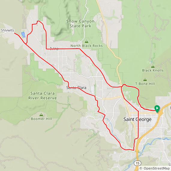
We'll meet just off I-15 Exit 8 in the heart of St. George, and we don't waste any time getting right into the climbing. We begin with a climb of about 350 feet in the first two miles up Red Hills Parkway, and you'll immediately see some of the breathtaking scenery that makes this such a wonderful place to ride. Next, we'll head up Snow Canyon Parkway through Ivins and into the desert community of Kayenta with its smooth, almost-empty roads that attract cyclists from all around.

We'll ride out to the Shivwits Band of Paiute Indians reservation for our rest stop, and then we'll head back through Ivins and into Santa Clara on a glorious new bike lane that was recently added. We'll head back into St. George and slowly climb through the historic downtown district on our way to our final climb, back up Red Hills Parkway in the other direction and then back down to our meeting point.

Ride With GPS reports about 2,000 feet of climbing for this ride. Food, water, and toilets are available inside Maverik. Park and meet in the rear parking lot behind the gas station, near Denny's. Look for the ALC banner!

Nevada riders, note: St. George is on Mountain Time, one hour ahead of Las Vegas.

Click here to RSVP now
Please RSVP so I can plan appropriately.

Three Sisters and Wetlands Park (11/19/2016)

Date: Saturday, November 19
Meet time: 8:30 a.m.
Ride-out time: 9:00 a.m.
Meeting place: Fiesta Henderson, 777 West Lake Mead Parkway (map)
City: Henderson, Nevada
Rain policy: Rain cancels; make-up date is Nov. 20
Pace: 2 - medium pace
Terrain: 3 - rolling hills with some steep climbs
Miles: 36

For our first Henderson ride of this season, we'll spend much of the day on some of the area's excellent paved pathways. And when I say "pathway," don't think it's all flat and easy -- there are a couple of "interesting" climbs on today's route.

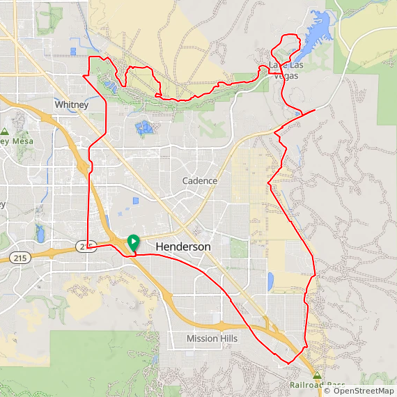
We start with a few miles of very gentle climbing on the Union Pacific Railroad Trail, which gains about 400 feet of elevation on its way to the edge of Henderson. Then we'll make a quick connection under 515/95/93 to join the River Mountains Trail, and we'll conquer the Sisters, a series of short but moderately steep hills, but in the easier direction. We'll take our rest stop near Lake Las Vegas area, and then we'll circle around the north hills of Lake Las Vegas before we pick up the Wetlands Park trail, 6 miles of rollercoaster-type hills up and down and around the desert. After that, it's a bit of city-style riding on Gibson Road before we again pick up the Union Pacific trail for our last mile back to the Fiesta.

Ride With GPS reports about 1,700 feet of climbing for this ride. The Fiesta is freeway-convenient, right at the end of the 215 where it meets 95. Toilets, water, and a Starbucks are available inside the Fiesta. Park and meet in the rear parking lot partway up the hill on Fiesta Henderson Blvd., near the train tracks. Look for the ALC banner!

Click here to RSVP now
Please RSVP so I can plan appropriately.

Blue Diamond loop (11/5/2016)

Date: Saturday, November 5
Meet time: 8:00 a.m.
Ride-out time: 8:30 a.m.
Meeting place: McGhie's, 4035 S. Fort Apache Rd. (map)
City: Las Vegas, Nevada
Rain policy: Rain cancels; make-up date is November 6
Pace: 2 - medium pace (10-12mph)
Terrain: 2 - rolling hills
Miles: 31

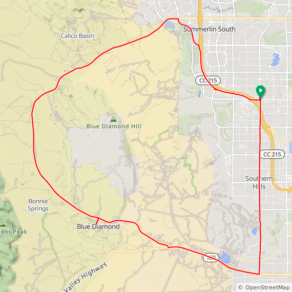
We'll do the loop out to Blue Diamond and back, this time in the direction with the more gradual but somewhat longer climb -- only 1,300 feet over 15 miles, so it's really not too bad at all. And after that, it's all downhill for the rest of the ride! Experienced riders who want a more robust ride can optionally add the Red Rock Canyon scenic loop for another 1,200 feet and 13 miles.

McGhie's won't be open early in the morning when we ride out, but park and meet in the back of the parking lot away from the main entrance. Look for the black pickup truck with all the ALC stuff! Several gas stations and mini-marts with toilets, food, and water are nearby.

You don't have to be registered for ALC 2017 to join us on our training rides! In fact, we hope that after you've ridden with us, you'll be motivated to join us for the main event from San Francisco to Los Angeles next June ... registration for ALC 2017 is still open.

Click here to RSVP now
Please RSVP so I can plan appropriately.

ALC 2017 Las Vegas kickoff ride (10/15/2016)

Date: Saturday, October 15
Meet time: 8:00 a.m.
Ride-out time: 8:30 a.m.
Meeting place: McGhie's, 4035 S. Fort Apache Rd. (map)
City: Las Vegas, Nevada
Rain policy: Rain cancels; make-up date is October 16
Pace: 2 - medium pace (10-12mph)
Terrain: 2 or 3 - rolling hills with some steep climbs
Miles: 23 or 34

Let's ride! The ALC 2017 training season is officially underway. And we start our season in Las Vegas with a classic route ... and with two options, one with a bit of climbing, and one with a bit more climbing.

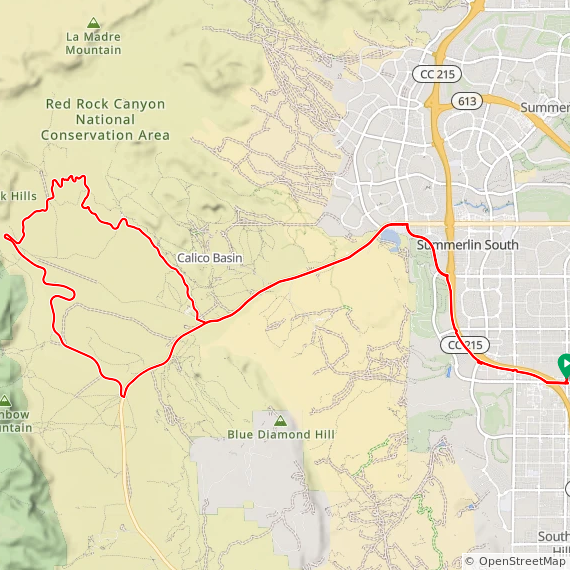
Red Rock Canyon is one of the most popular cycling destinations in the entire Las Vegas area, and for good reason. Today we'll start in southwest Las Vegas and head up the I-215 trail for a few miles before we pick up Charleston Blvd. to head west out of civilization and into the canyon. We'll slowly climb most of the way -- nothing too terribly steep, and if the wind is just right, you might not even realize that you're climbing much at all.

When we get to the entrance for the 12-mile Red Rock Canyon scenic loop, you've got an option. You can head just a couple more miles up the main highway, turn around at the canyon overlook, and head back to Las Vegas the way you came. That will give you a ride of about 23 miles and about 1,300 feet of climbing. Or, if you've got a few cycling miles under your belt, you can tackle the scenic loop, return to the canyon overlook, and rejoin the 23-mile riders back to Las Vegas for a total ride of about 34 miles and a more robust 2,500 feet of climbing. The scenic loop contains some moderately steep climbs and descents and is for experienced cyclists.

McGhie's won't be open early in the morning when we ride out, but park and meet in the back of the parking lot away from the main entrance. Look for the black pickup truck with all the ALC stuff! Several gas stations and mini-marts with toilets, food, and water are nearby.

You don't have to be registered for ALC 2017 to join us on our training rides! In fact, we hope that after you've ridden with us, you'll be motivated to join us for the main event from San Francisco to Los Angeles next June ... registration for ALC 2017 is still open.

Click here to RSVP now
Please RSVP so I can plan appropriately.

Mystery ride to Jean (4/23/2016)

Date: Saturday, April 23
Meet time: 7:00 a.m. Note earlier meet time!
Ride-out time: 7:30 a.m.
Meeting place: Sunset Station, 1301 W. Sunset Rd. (map)
City: Henderson, Nevada
Rain policy: Rain cancels; make-up date is April 24
Pace: 3 - medium-brisk pace (12-15mph)
Terrain: 2 - rolling hills
Miles: 60

With only about a half-dozen turns in the space of 60 miles, this is one of our least complicated routes of the entire season, as we head down old U.S. 91 -- roughly parallel to I-15 and with almost no traffic -- to the Gold Strike at Jean, turn around, come back up the old highway, and return to Henderson on St. Rose Parkway. So why the mystery?

The weather is the mystery ... specifically, the wind. If the wind is light, this is a superbly mellow ride with no big hills and a lot of open-road cycling similar to that in the middle days of the event in June. If the wind is stronger and out of the north or south, then half of our day will be challenging and the other half will be quite literally a breeze. And if the wind is strong and out of the east or west, we might be fighting nasty crosswinds for almost the entire day. But no matter how you slice it, the final 20 miles of the day are all gently downhill.

Ride With GPS reports only about 1,900 feet of climbing for this ride. Toilets, water, and a Starbucks (of course) are available inside Sunset Station. Park and meet in the east-side parking lot, off Marks Street near the hotel entrance. Follow the signs for "Meeting Rooms," and look for the black truck with ALC goodies.

Click here to RSVP now
Please RSVP so I can plan appropriately.

Hoover Dam and Bridge (3/26/2016)

Date: Saturday, March 26
Meet time: 8:00 a.m.
Ride-out time: 8:30 a.m.
Meeting place: Fiesta Henderson, 777 West Lake Mead Parkway (map)
City: Henderson, Nevada
Rain policy: Rain cancels; make-up date is March 27
Pace: 2 - medium pace
Terrain: 3 - rolling hills with some steep climbs
Miles: 54

Get ready for an epic ride all the way into Arizona! From our meeting point on the south edge of Henderson, we'll ride the Union Pacific and River Mountain trails into Boulder City for our first rest stop. After that, the real fun begins. We'll get on Highway 93 and quickly descend almost 1,000 feet (good practice for the morning of Day 6) into the Lake Mead National Recreation Area. We'll stay on 93 as it becomes a freeway (also good practice for the event) and descends even more to the Mike O'Callaghan-Pat Tillman Memorial Bridge, which takes us across the state line into Arizona.

When we reach the first exit in Arizona, we'll leave the freeway, turn around, and head back across the bridge on the wide, smooth shoulder ... and where the throngs of sightseers on the separate walkway will undoubtedly gawk at the sight of bicyclists and might even take a picture of you to show the folks back home.

As if that weren't enough, next we'll descend all the way down to Hoover Dam itself and ride across the top of the dam, just back across the state line into Arizona, before turning around and beginning the moderately steep climb back up to Highway 93 and the entrance to the Lake Mead scenic drive.

But wait, there's more! We'll then ride the River Mountains Trail (no fee for riding the trail) along the edge of Lake Mead and all the way around the recreation area for about 14 miles and up to the Lake Las Vegas area. (This is a more gentle ascent than the steep hill on Highway 93 that we descended earlier in the day.) And after a final rest stop, it's an easy ride (albeit with a bit more traffic) back to the Fiesta.

Ride With GPS reports about a robust 4,200 feet of climbing for this ride. Toilets, water, and a Starbucks (of course) are available inside the Fiesta. Park and meet in the rear parking lot partway up the hill on Fiesta Henderson Blvd. just past the parking garage, toward the train tracks.

Important: This ride passes through a mandatory Homeland Security checkpoint on the access road to Hoover Dam. Although ID checks and searches are rare, bring a photo ID and, if you aren't a U.S. citizen, proof of citizenship.

Click here to RSVP now
Please RSVP so I can plan appropriately.

Lake Mead (2/27/2016)

Date: Saturday, February 27
Meet time: 8:30 a.m. Note earlier meet time!
Ride-out time: 9:00 a.m.
Meeting place: Sunset Station, 1301 W. Sunset Rd. (map)
City: Henderson, Nevada
Rain policy: Rain cancels; make-up date is Feb. 28
Pace: 2 - medium pace
Terrain: 3 - rolling hills with some steep climbs
Miles: 50

The Lake Mead National Recreation Area offers superb and scenic road cycling just minutes away from the hustle and bustle of metro Las Vegas. Today, we'll explore one corner of that vast area as we descend to the lake and conquer the climb back up through Boulder City.

Before we get to Lake Mead, however, we'll start with a special short bonus climb: the loop around Lake Las Vegas and then back up to Lake Mead Parkway. That will get us to our first rest stop of the day at the River Mountains Bike Shop. After that, we'll go down the hill to the Lake Mead entrance gate, where you'll need to either pay a $5 cyclist fee or show a valid entrance pass (such as the nationwide America the Beautiful pass). This is our gateway to Lakeshore Road, 12 miles of rolling hills that trend gradually downward to the lake and provide striking views of the lake and its "bathtub ring."

Since we descend to the lake, we also have to climb back up. We'll use the River Mountains Trail, which is a longer but far more gentle climb that the hill on Highway 93 that motorists use. When we reach Boulder City, we'll take another rest stop, and then we'll bypass the steepest part of the trail (the part we did on our last ride) and take a short cut to pick up the trail again on the other side of the city. We'll deal with Railroad Pass again (hoping that the winds aren't as strong this time), and after that it's all downhill back to Henderson.

Ride With GPS reports about 2,800 feet of climbing for this ride. Toilets, water, and a Starbucks (of course) are available inside Sunset Station. Park and meet in the east-side parking lot, off Marks Street near the hotel entrance. Follow the signs for "Meeting Rooms," and look for the black truck with ALC goodies.

Click here to RSVP now
Please RSVP so I can plan appropriately.

Boulder City (2/6/2016)

Date: Saturday, February 6
Meet time: 9:00 a.m.
Ride-out time: 9:30 a.m.
Meeting place: Sunset Station, 1301 W. Sunset Rd. (map)
City: Henderson, Nevada
Rain policy: Rain cancels; make-up date is Feb. 7
Pace: 2 - medium pace
Terrain: 3 - rolling hills with some steep climbs
Miles: 42

Shake the cobwebs off the derailleurs, and join us as we head south to Boulder City for a fun day on roads, paths, and yes, even a few interesting hills.

After a few miles of gentle warmup, we start with the climb up Horizon Ridge to Paradise Hills, and we'll make our way to the River Mountains Trail. Then we'll head west up and over Railroad Pass, alongside U.S. 93, and into the outskirts of Boulder City. We'll do a big loop around the city, starting with a long and gradual descent toward the airport and continuing with a gentle climb up Georgia Avenue and over to the Nevada Way historic district and our rest stop at mile 21.

After that, we'll explore a little more of the city before making our way under U.S. 93 to again pick up the River Mountains Trail. We'll ride the trail -- which includes the twisty, moderately steep climb to the trail's high point at an elevation of just under 2,700 feet -- all the way back to Henderson, where we'll hop on the Union Pacific Trail and take it to the 215.

Ride With GPS reports about 2,000 feet of climbing for this ride. Toilets, water, and a Starbucks (of course) are available inside Sunset Station. Park and meet in the east-side parking lot, off Marks Street near the hotel entrance. Follow the signs for "Meeting Rooms," and look for the black truck with ALC goodies.

Click here to RSVP now
Please RSVP so I can plan appropriately.

St. George Christmas orphans (12/25/2015)

CANCELED - unfavorable weather
Date: Friday, December 25
Meet time: 11:15 a.m.
Ride-out time: 11:30 a.m.
Meeting place: Crosby Family Confluence Park, 2099 S. Convention Center Drive (map)
City: St. George, Utah
Rain policy: Rain or ice cancels
Pace: 2 - medium pace (10-12 mph)
Terrain: 1 - mostly flat
Miles: 25

Yes, even in southern Utah, not everyone is able to be with their family or loved ones on Christmas. No point in sitting home alone; come on out and ride. (And even if you are with friends and family, join us after unwrapping the presents, and you'll still get home in time for dinner.)

Because it's Christmas (and because the early forecasts suggest it might be a bit chilly), today's route is relatively easy, with only a couple of mild hills. We start by heading east on the Virgin River Trail until it ends, then a little bit along Riverside Drive to join up with the new segment of the trail, extending past Sullivan Park and along the newest segment east of town. When the paved trail ends, we'll ride an easy 0.3 mile of sand/gravel to the "Bridge to Nowhere," and then head back into Washington via the Washington Dam Road. We'll eventually make our way to 2450 South and pick up St. James Lane to the Bloomington Hills Trail. Finally, we'll scoot under I-15 through the roundabouts (light holiday traffic, so no worries), ride past Bloomington Park, and then pick up the rest of the Virgin River Trail for our return to Confluence Park.

If there is significant rain on Christmas Eve, I will modify the route to not use the sand/gravel section.

We will not ride if the temperature at meet time is 32 degrees or below. Please RSVP if you're planning to attend; if I have zero RSVPs by December 23, I might cancel the ride. Bring whatever food you want or need; don't plan on anything being open along the route.

Everyone gets a detailed route sheet, and you're free to ride at your own pace or with others, whatever you wish.

Click here to RSVP now
Please RSVP so I can plan appropriately.

New Year's Day at Sunrise Mountain (1/1/2016)

Date: Friday, January 1
Meet time: 9:00 a.m.
Ride-out time: 9:30 a.m.
Meeting place: Sunset Station, 1301 W. Sunset Rd. (map)
City: Henderson, Nevada
Rain policy: Rain cancels
Pace: 2 - medium pace
Terrain: 3 - rolling hills with some steep climbs
Miles: 40

Happy New Year! Start your 2016 cycling off with a bang on this scenic and stimulating ride into the Lake Mead National Recreation Area.

We depart from Sunset Station, just off Hwy. 95, and we'll start with an easy spin over to Clark County Wetlands Park. (If it's cold, watch for the fascinating sight of steam rising from the Las Vegas Wash.) This takes us to Hollywood Blvd., where we'll slowly climb to the east side of North Las Vegas and our first rest stop.

Then, get ready to climb! Lake Mead Blvd. ascends 2.1 miles and gains about 500 feet on its way to the summit of Sunrise Mountain; it's got a couple of mildly steep parts (more like Evil Twins, not like Quadbuster), so you'll quickly forget about any morning chill that might be lingering. After that, get ready for fun: A descent of more than 6 miles (much of it on brand-new pavement with a gloriously smooth, wide shoulder) takes us into the Lake Mead NRA. This tollbooth is often closed on holidays, but if it's open, be prepared to pay a $10 cyclist fee (good for seven consecutive days, so come back later on your own) or show a valid pass. (The America the Beautiful interagency pass is valid, but the Red Rock-only pass is not.)

Take in the scenery as we ride through the recreation area and connect with Northshore Road, which rises and then descends steeply as it crosses Las Vegas Creek. This begins our other big climb of the day: 2.3 miles with an elevation gain of about 450 feet as we leave the recreation area and begin riding Lake Mead Parkway back toward Henderson. Again, a couple of short and mildly attention-getting parts, but nothing stupidly steep. After all, it's New Year's Day!

Our final 10 miles are mostly easy as we ride the smooth bike lane of Lake Mead Parkway back to Warm Springs Road (with a new buffered bike lane most of the way!) and our return to Sunset Station. Presto, you've already bagged 40 miles for 2016!

Ride With GPS reports about 1,900 feet of climbing for this ride. Toilets, water, and a Starbucks are available inside Sunset Station. Park and meet in the east-side parking lot, off Marks Street near the hotel entrance. Follow the signs for "Meeting Rooms," and look for the black truck with ALC goodies.

Click here to RSVP now
Please RSVP so I can plan appropriately.

Boulder City (12/12/2015)

Date: Saturday, December 12
Meet time: 9:00 a.m.
Ride-out time: 9:30 a.m.
Meeting place: Fiesta Henderson, 777 West Lake Mead Parkway (map)
City: Henderson, Nevada
Rain policy: Rain cancels; make-up date is Dec. 13
Pace: 2 - medium pace
Terrain: 3 - rolling hills with some steep climbs
Miles: 43

Today's ride starts again on the Union Pacific Trail, but today we'll turn off the trail after only about a mile and then gradually climb up Greenway Road into the Paradise Hills area for a little early fun on the rolling hills of this residential area.

Next, we'll pick up the River Mountains Loop Trail and head west up and over Railroad Pass, alongside U.S. 93, and into the outskirts of Boulder City. We'll do a big loop around the city, starting with a long and gradual descent toward the airport and continuing with a gentle climb up Georgia Avenue and over to the Nevada Way historic district and our first rest stop at mile 18.

After that, we'll explore a little more of the city before making our way over to U.S. 93 for a descent of more than 3 miles and about 900 feet into the Lake Mead National Recreation Area. If we descend that much, we of course have to climb that much ... but we'll climb much of the way back on the much gentler (and, therefore a little longer) River Mountains Trail. We eventually have to do some of the climb on U.S. 93 (the flood channel doubles as the bike path, so we might use that if it hasn't been raining), and we'll take another rest stop partway up the hill at mile 30.

We'll take Industrial Road to bypass the steepest and highest part of the River Mountains Trail (don't worry, that's coming up on a future ride), and we'll eventually pick up the trail again for the short climb back over Railroad Pass. After that, the final 8 miles of the ride are almost all gently downhill!

Ride With GPS reports about 2,400 feet of climbing for this ride. Toilets, water, and a Starbucks (of course) are available inside the Fiesta. Park and meet in the rear parking lot partway up the hill on Fiesta Henderson Blvd. just past the parking garage, toward the train tracks.

Click here to RSVP now
Please RSVP so I can plan appropriately.

Once around St. George (12/5/2015)

Date: Saturday, December 5
Meet time: 11:00 a.m. MST
Ride-out time: 11:30 a.m. MST
Meeting place: Starbucks, 1091 N. Bluff St. (map)
City: St. George, Utah
Rain policy: Rain or ice cancels
Pace: 2 - medium pace (10-12 mph)
Terrain: 2 - rolling hills
Miles: 42

Today's ride is a simple loop around St. George. But because this is St. George, that means there's a bit of climbing ... and you'll be rewarded with a wide variety of outstanding scenery and generally low-traffic roads.

We begin by heading south toward Bloomington, across the Virgin River, in for a quick and early rest stop at mile 8, and up to River Road. From there, we'll make our way to ride 7 miles of the Southern Parkway, a glorious freeway-type highway that has smooth, wide shoulders and often has more cyclists than motorists. (It's also good low-stress training for the freeway segments of the event in June.) And if skies are clear, you'll be treated to excellent views of Signal Peak, the region's highest mountain at 10,364 feet. (Sorry, no roads go all the way to the top.)

Next, we'll ride northbound through Washington City to our second rest stop at mile 28 near I-15. We'll then head back toward St. George, but we'll take a little detour into the Green Spring residential area along the way for a fun climb and an even more fun descent.

We've saved our pièce de résistance for last! Southern Utah cyclists know Red Hills Parkway well. If you're visiting, you'll be amazed by the views of the red rocks and the desert as we top out at just over 3,200 feet of elevation before our final descent back to our meeting point.

If you're not up for the full 42 miles, there are plenty of ways to make the ride shorter. You don't have to be registered for ALC 2016 to ride ... although we might try to persuade you to think about ALC 2017 if you're not.

Ride With GPS reports about 2,200 feet of climbing for this ride. We meet at a Starbucks, and there's plenty of other food and drink nearby. I've made the meet time purposely late so that: (1) you'll have plenty of time to drive here in the morning if you wish, and (2) we'll hopefully avoid the worst of the autumn morning chill. We're less than two hours of driving time from the Spaghetti Bowl interchange in Las Vegas!

We will not ride if the temperature at meet time is 32 degrees or below.

Important note for Nevada riders: St. George is on Mountain Standard Time, one hour ahead of Las Vegas.

Join us and find out how our rides are different! We obey traffic laws and stop signs, we ride single-file, we don't paceline, we never-ever-EVER pass others on the right, we help one another, and we make sure everyone has a GREAT ride. Everyone gets a detailed route sheet, and you're free to ride at your own pace or with others, whatever you wish.

Click here to RSVP now
Please RSVP so I can plan appropriately.

Clark County Wetlands Park (11/21/2015)

Date: Saturday, November 21
Meet time: 9:00 a.m.
Ride-out time: 9:30 a.m.
Meeting place: Fiesta Henderson, 777 West Lake Mead Parkway (map)
City: Henderson, Nevada
Rain policy: Rain cancels; make-up date is Nov. 22
Pace: 2 - medium pace
Terrain: 2 - rolling hills
Miles: 36

More than half of today's ride is on paved trails that are part of the excellent cycling infrastructure in the southeast valley. When you think of "paved trail," you might think of flat and easy, but that's not always the case around here!

We start with a few miles of very gentle climbing on the Union Pacific Railroad Trail, which gains about 400 feet of elevation on its way to the edge of Henderson. Then we'll make a quick connection under 515/95/93 to join the River Mountains Trail, and we'll conquer the first three of the Seven Sisters, a series of short but moderately steep hills. After a short ride on Lake Mead Parkway to visit our first rest stop, we'll head into the Lake Las Vegas area, where we'll pick up the Wetlands Park trail, 6 miles of rollercoaster-type hills up and down and around the desert. Then it's back into civilization for our second rest stop, and a bit of riding on Boulder Highway and Gibson Road before we again pick up the Union Pacific trail for our last mile back to the Fiesta.

Ride With GPS reports about 1,400 feet of climbing for this ride. Toilets, water, and a Starbucks (of course) are available inside the Fiesta. Park and meet in the rear parking lot partway up the hill on Fiesta Henderson Blvd., near the train tracks.

Click here to RSVP now
Please RSVP so I can plan appropriately.

ALC 2016 Southern Utah kickoff (11/14/2015)

Date: Saturday, November 14
Meet time: 10:30 a.m. MST
Ride-out time: 11:00 a.m. MST
Meeting place: Starbucks, 1091 N. Bluff St. (map)
City: St. George, Utah
Rain policy: Rain cancels; make-up date is Nov. 15
Pace: 2 - medium pace (10-12 mph)
Terrain: 2 - rolling hills
Miles: 32

Southern Utah has some of the West's most amazing road cycling, and the ALC 2016 southern Utah training rides will take you to some of the most scenic and amazing places. Our season kicks off today with a red rock excursion past Snow Canyon into Ivins, a gentle climb into the community of Kayenta, and to our rest stop on tribal land of the Shivwits Band of Paiutes.

Next, we'll ride through Santa Clara and past some volcanic lava fields before reaching downtown St. George, where we'll ride past the temple before our final spectacular climb of the day to the top of Red Hills Parkway and breathtaking views of the hills before our final grand descent back to our meeting point.

If you're not up for the full 32 miles, there are plenty of ways to make the ride shorter. And all paces are welcome; we'll make sure nobody gets left behind. You don't have to be registered for ALC 2016 to ride ... although we might try to persuade you to think about ALC 2017 if you're not.

Ride With GPS reports about 1,670 feet of climbing for this ride. We meet at a Starbucks, and there's plenty of other food and drink nearby. I've made the meet time purposely late so that: (1) you'll have plenty of time to drive here in the morning if you wish, and (2) we'll hopefully avoid the worst of the autumn morning chill. We're less than two hours of driving time from the Spaghetti Bowl interchange in Las Vegas!

Important note for Nevada riders: St. George is on Mountain Standard Time, one hour ahead of Las Vegas.

Join us and find out how our rides are different! We obey traffic laws and stop signs, we ride single-file, we don't paceline, we never-ever-EVER pass others on the right, we help one another, and we make sure everyone has a GREAT ride. Everyone gets a detailed route sheet, and you're free to ride at your own pace or with others, whatever you wish.

Click here to RSVP now
Please RSVP so I can plan appropriately.

Blue Diamond out and back (11/7/2015)

Date: Saturday, November 7
Meet time: 9:00 a.m.
Ride-out time: 9:30 a.m.
Meeting place: Vista Commons, Charleston Blvd. at Desert Foothills Drive (map)
City: Las Vegas, Nevada
Rain policy: Rain cancels; make-up date is Nov. 8
Pace: All paces welcome
Terrain: 2 - rolling hills
Miles: 25

The first official ALC Las Vegas training ride of the 2016 season is here! And we begin with one of the valley's most popular and scenic cycling routes: Red Rock Canyon Road. Because the season is still young (even if some of us are not), we're doing only part of it today -- the part out to Blue Diamond and back.

From our start in Summerlin, we begin climbing right away, but it's mostly gentle and not steep at all. Before you know it, you've climbed about 700 feet to the canyon overlook, and from there it's mostly downhill all the way into our rest stop in Blue Diamond.

Our route back is exactly the way we went out, so it's just about impossible to get lost. And if you're not feeling like the whole 25 miles yet, you can turn around at any point. The ride to the canyon overlook and back is a robust 13 miles. And all paces are welcome; we'll make sure nobody gets left behind. You don't have to be registered for ALC 2016 to ride ... although we might try to persuade you to think about ALC 2017 if you're not.

Ride With GPS reports about 1,360 feet of climbing for this ride. We meet in a big shopping center, so you'll be near every type of food and drink you might want. Park and meet in back of Albertsons. DO NOT park in any of the 2-hour signed customer parking zones, or your vehicle might be towed.

Join us and find out how our rides are different! We obey traffic laws and stop signs, we ride single-file, we don't paceline, we never-ever-EVER pass others on the right, we help one another, and we make sure everyone has a GREAT ride. Everyone gets a detailed route sheet, and you're free to ride at your own pace or with others, whatever you wish.

Click here to RSVP now
Please RSVP so I can plan appropriately.

ALC 2016 Las Vegas unofficial kickoff ride (10/17/2015)

Date: Saturday, October 17
Meet time: 9:00 a.m.
Ride-out time: 9:30 a.m.
Meeting place: Fiesta Henderson, 777 West Lake Mead Parkway (map)
City: Henderson, Nevada
Rain policy: Rain cancels; make-up date is Oct. 18
Pace: All paces welcome
Terrain: 2 - rolling hills
Miles: 25

The ALC 2016 training season is underway across California, so it's time to have a kickoff ride in the Las Vegas Valley as well! Just like the official rides, this route is about 25 miles with not a lot of climbing. And all paces are welcome; we'll make sure nobody gets left behind on this route that combines paved paths with on-road riding. You don't have to be registered for ALC 2016 to ride ... although we might try to persuade you if you're not.

From our starting point near the 215/515 junction, we'll ride the Union Pacific Railroad Trail very gently upward to the end of the paved section, and then we'll cut over to the River Mountains Trail for the long, gradual descent back into the valley, with a toilet and water stop along the way. We'll continue our descent into the Lake Las Vegas area (with a couple of short hills on the trail, but it's OK to walk them), and we'll take another brief water and toilet stop at Terrazza Park before heading back on the new section of Galleria Drive before our last little gentle climb of about 200 feet back to the Fiesta.

Ride With GPS reports about 1,170 feet of climbing for this ride. Toilets, water, and a Starbucks (of course) are available inside the Fiesta. Park and meet in the rear parking lot partway up the hill on Fiesta Henderson Blvd., near the train tracks.

Join us and find out how our rides are different! We obey traffic laws and stop signs, we ride single-file, we don't paceline, we never-ever-EVER pass others on the right, we help one another, and we make sure everyone has a GREAT ride. Everyone gets a detailed route sheet, and you're free to ride at your own pace or with others, whatever you wish.

Click here to RSVP now
Please RSVP so I can plan appropriately.

Endings and beginnings

Today I completed my final weekend of riding with AIDS/LifeCycle in the Bay Area: about 132 miles with 10,000 feet of climbing. (Yikes! I think that's the most climbing I've ever done in two consecutive days.)

I attended my first ALC training ride on May 14, 2005 (but didn't ride in the event until 2006), and since then I've racked up exactly 70,853 miles on the bike. Doing these rides has brought countless joy to my life, and I've been touched by the many stories I've heard from those with whom I've had the privilege and honor to ride.

My next chapter begins later this week, but don't be surprised if at some point in the future you again see my name as a ride leader on the ALC calendar ... or maybe even see me on the event.

I'm not riding in ALC this year, so I don't have a fundraising account. But I encourage you to support your favorite cyclist or roadie in ALC 2015 so that SFAF and the Los Angeles LGBT Center can continue to do their vital work.

Quadrophenia #8: Old La Honda Plus (4/18/2015)

Date: Saturday, April 18
Meet time: 8:30 a.m.
Ride-out time: 9:00 a.m.
Meeting place: Stevenson Elementary School, 750 San Pierre Way (map)
City: Mountain View
Rain policy: Rain cancels
Pace: 2 - moderate pace (10-12 mph)
Terrain: 4 - some steep hills; one long climb
Miles: 65

Description:
Our big climb of the day is legendary Old La Honda Road, viewed by many as the benchmark climb of the Peninsula, the place where you go year after year to gauge your progress. How popular is it? Strava has logged more than 103,000 climbs up OLH! But today's ride isn't just Old La Honda; the "plus" is that it comes in the middle of today's ride, with a healthy serving of hills both before and after the main event.

We start by heading to Palo Alto and La Cresta Drive. Next, it's into Los Altos Hills for Natoma Road. Then, it's the back way into Neary Quarry. Then Ravensbury. And, mercifully, a rest stop. We might have cycled 18 miles so far, but we're actually only about 5 miles from our starting point!

Rested and refueled, we're ready for more. Barley Hill. Elena and Taaffe. Arastradero Nature Preserve. And finally we're ready for Old La Honda, a moderate 3.1-mile climb that gains about 1,250 feet without ever becoming stupidly steep. And today we'll also get to enjoy the amazingly scenic descent down the backside of Old La Honda as well! This takes us to Highway 84, where we'll do the very gentle 3-mile climb back to the summit before descending into Woodside and our second rest stop.

We're almost done, but we've got a couple more little pieces of fun on the way back. We'll revisit the Southgate/Eleanor hill we did a few weeks ago, and we'll climb the mostly gentle Concepcion Road in Los Altos Hills. That leaves just 7 miles to home, and it's almost all flat or downhill. What a workout!

Ride With GPS reports about 5,400 feet of climbing for this ride. Worried about doing Day on the Ride the day after this? You can do a version of this ride with a little less "plus," but still 53 miles and 3,800 feet of moderate climbing.

Toilets and water are available nearby at Stevenson Park; Safeway and Jack In The Box are a half-mile away at Shoreline Blvd.

Click here to RSVP now
RSVPs are recommended but not required.

Quadrophenia #7: Montebello (4/4/2015)

Date: Saturday, April 4
Meet time: 8:30 a.m. Earlier meet time!
Ride-out time: 9:00 a.m.
Meeting place: Stevenson Elementary School, 750 San Pierre Way (map)
City: Mountain View
Rain policy: Rain cancels
Pace: 2 - moderate pace (10-12 mph)
Terrain: 4 - some steep hills; one long climb
Miles: 58

Description:
So far this season, all of our climbs have been relatively short. Today, that changes. Montebello Road rises from Stevens Canyon on a climb of 5.2 miles to a top elevation of about 2,560 feet. (That's just about as high as Mount Tamalpais!) But you can think of it as three separate climbs. The first two miles average 9% and are moderately challenging. The next mile averages only 3% and offers some relief. The final two miles average only 8%, but there are a few very steep (double-digit) pitches on the way to an epic dead end with amazing views of the valley. Your reward for all that climbing? An epic 5.2-mile descent, but watch out for wildlife, oncoming traffic, and debris.

But if Montebello were our only destination of the day, that wouldn't be a very long ride. So we've packed today's ride with a few extra bonus climbs both before and after Montebello. We've got the backside of Pierce Road from Highway 9 to the Mountain Winery (the easier direction), and the backside of Mount Eden (OK, not so easy). We'll finish with a reprise of West Loyola Drive, Barley Hill, Quinnhill Road and Valley View Drive ... but they're at the end of the ride this time, and you might notice some difference in how you feel about them!

Ride With GPS reports about 4,300 feet of climbing for this ride. Toilets and water are available nearby at Stevenson Park; Safeway and Jack In The Box are a half-mile away at Shoreline Blvd.

Click here to RSVP now
RSVPs are recommended but not required.

Quadrophenia #6: All-New Epic-er Dead Ends! (3/21/2015)

Date: Saturday, March 21
Meet time: 9:00 a.m.
Ride-out time: 9:30 a.m.
Meeting place: Stevenson Elementary School, 750 San Pierre Way (map)
City: Mountain View
Rain policy: Rain cancels
Pace: 2 - moderate pace (10-12 mph)
Terrain: 4 - several steep climbs
Miles: 56

Description:

Word is that you overachievers apparently like epic dead ends. So our crack team of researchers has spent countless hours and countless Shot Bloks to scour the backroads and byways of Cupertino, Saratoga, and Los Gatos to find seven, count 'em, seven all-new even Epic-er Dead Ends that have never been on any training ride! Saddle on up, don't forget a generous serving of butt cream, and get ready for a hill-climbing (and hill-descending) extravaganza.

We get a 9-mile gentle warmup on our way to Cupertino for the day's first challenge: the combination of Lindy Lane and Canyon View Circle. It's only 0.6 mile at 9% average, but the final 0.2 mile is a wake-you-up 16% average. Good morning! It's less than 2 miles to the next hill of joy: the combination of Parker Ranch Road and Vista Arroyo Court (0.4 mile, 10%) with another stunning view of the valley waiting for you at the top. Our next destination takes us partway up Pierce Road to a turnoff we've passed countless times: Old Oak Way. You can see the intimidating beginning (0.1 mile, 15%) from Pierce, but it gradually levels off into a still-invigorating climb of 0.7 mile at 9%. We've earned our first rest stop, this time in Saratoga Village. Be sure to refuel!

After the rest stop, we start heading toward Los Gatos, but we'll turn off Highway 9 and up Pepper Lane to one of the great hidden gems: CaƱon Drive. It's 0.9 mile at only 6% average, but most of the climbing comes near the end of the public road where we turn around. It's not the most technically exciting climb or descent, but it's an incredibly scenic valley where few cyclists ever venture.

Don't let that relatively easy climb lull you into a false sense of complacency about the second half of our ride. After passing through downtown Los Gatos, the fun resumes in earnest. First is the combination of Jackson Street and Central Avenue (0.4 mile, 9%), followed very closely by the rarely-visited Foster Road (0.7 mile, 11%) and our highest elevation of the day at about 950 feet. We get a glorious descent down to Kennedy Road, and we start the traditional Kennedy climb, but wait ... what's this? We're turning off Kennedy?!

Yup. Teresita Road is only 0.5 mile to the end of the public part, and it's officially rated at "only" 11% average, but it has some very steeply banked curves and an extended section near the top that runs at 18%-20%. (Our research team couldn't make it to the top without stopping.) There's a reason why, as of this writing, only 134 Strava cyclists have ever ventured here! The descent back down to Kennedy is very steep, twisty, and technical (but the road is in good condition), and you need to control your speed with extreme care. Be sure your brakes are in excellent working order!

Let's see ... that's, yup, seven Epic-er Dead Ends. What? Now we're climbing the rest of Kennedy? But of course. And are we heading back to Los Gatos by climbing Shannon? Hardly! We finish by climbing Santa Rosa Drive (0.3 mile, 14%), which is a dead end for cars but is gloriously open to us and connects to a secret passage that magically drops us in very short and steep order right down into the heart of south San Jose. You've earned that second rest stop!

With 17 miles left in the ride, sure, you can't get from Los Gatos to Mountain View without at least a couple of little rolling hills, but they're almost not even worth mentioning after everything we've been through today. We finish with the gentle descent all the way through Sunnyvale down to Evelyn Avenue, which we follow back to downtown Mountain View, and then the short little hop up the street to Stevenson Elementary. We'll make sure that today's dessert tray will be fabulous for all the fabulous riders who conquer this challenging route!

Ride With GPS reports about 4,350 feet of climbing, and most of that is packed into the middle 28 miles of the ride. Toilets and water are available nearby at Stevenson Park; Safeway and Jack In The Box are a half-mile away at Shoreline Blvd.

Click here to RSVP
RSVPs are requested but not required.